You are here: Home > Network List > OX - North-East Italy Seismic Network Stations List
> Station CIMO Cimolais > Earthquake Result Viewer
CIMO Cimolais - Earthquake Result Viewer
| Earthquake location: |
Western Iran |
| Earthquake latitude/longitude: |
32.3/49.8 |
| Earthquake time(UTC): |
2021/10/04 (277) 02:39:27 GMT |
| Earthquake Depth: |
10 km |
| Earthquake Magnitude: |
5.6 mww |
| Earthquake Catalog/Contributor: |
NEIC PDE/us |
|
| Network: |
OX North-East Italy Seismic Network |
| Station: |
CIMO Cimolais |
| Lat/Lon: |
46.31 N/12.44 E |
| Elevation: |
710 m |
|
| Distance: |
31.8 deg |
| Az: |
307.093 deg |
| Baz: |
102.875 deg |
| Ray Param: |
0.07894316 |
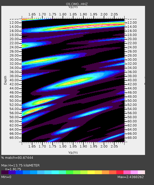
| Estimated Moho Depth: |
13.75 km |
| Estimated Crust Vp/Vs: |
1.92 |
| Assumed Crust Vp: |
6.35 km/s |
| Estimated Crust Vs: |
3.312 km/s |
| Estimated Crust Poisson's Ratio: |
0.31 |
|
| Radial Match: |
80.67444 % |
| Radial Bump: |
400 |
| Transverse Match: |
70.47957 % |
| Transverse Bump: |
400 |
| SOD ConfigId: |
25131211 |
| Insert Time: |
2021-10-18 02:52:16.695 +0000 |
| GWidth: |
2.5 |
| Max Bumps: |
400 |
| Tol: |
0.001 |
|

Signal To Noise
| Channel | StoN | STA | LTA |
| OX:CIMO: :HHZ:20211004T02:45:21.400001Z | 7.7972555 | 6.7165655E-7 | 8.614012E-8 |
| OX:CIMO: :HHN:20211004T02:45:21.400001Z | 4.3469467 | 3.899223E-7 | 8.970027E-8 |
| OX:CIMO: :HHE:20211004T02:45:21.400001Z | 4.8581424 | 4.450084E-7 | 9.1600526E-8 |
| Arrivals |
| Ps | 2.1 SECOND |
| PpPs | 5.9 SECOND |
| PsPs/PpSs | 8.0 SECOND |


