You are here: Home > Network List > US - United States National Seismic Network Stations List
> Station DGMT Dagmar, Montana, USA > Earthquake Result Viewer
DGMT Dagmar, Montana, USA - Earthquake Result Viewer
| Earthquake location: |
Western Iran |
| Earthquake latitude/longitude: |
32.3/49.8 |
| Earthquake time(UTC): |
2021/10/04 (277) 02:39:27 GMT |
| Earthquake Depth: |
10 km |
| Earthquake Magnitude: |
5.6 mww |
| Earthquake Catalog/Contributor: |
NEIC PDE/us |
|
| Network: |
US United States National Seismic Network |
| Station: |
DGMT Dagmar, Montana, USA |
| Lat/Lon: |
48.47 N/104.20 W |
| Elevation: |
0.0 m |
|
| Distance: |
96.3 deg |
| Az: |
342.898 deg |
| Baz: |
21.983 deg |
| Ray Param: |
0.04055336 |
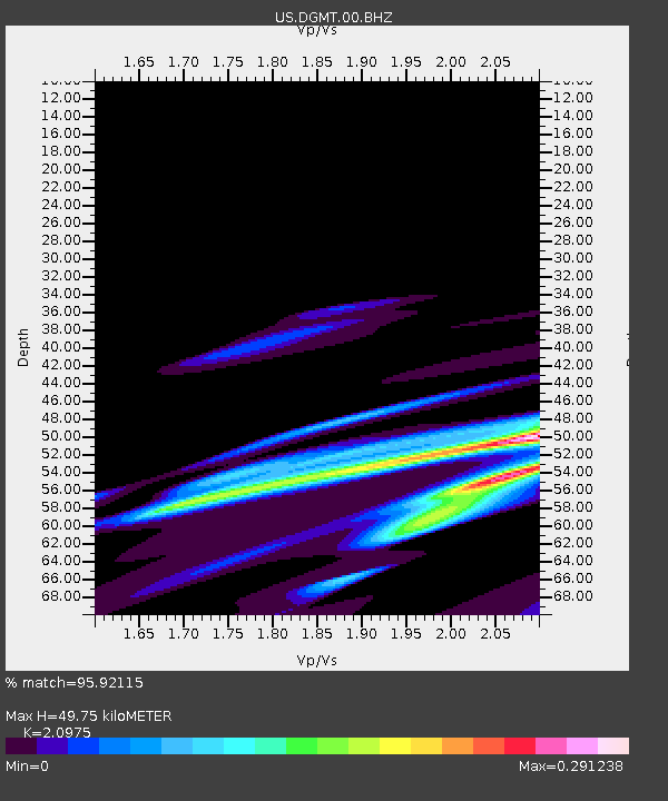
| Estimated Moho Depth: |
49.75 km |
| Estimated Crust Vp/Vs: |
2.10 |
| Assumed Crust Vp: |
6.438 km/s |
| Estimated Crust Vs: |
3.069 km/s |
| Estimated Crust Poisson's Ratio: |
0.35 |
|
| Radial Match: |
95.92115 % |
| Radial Bump: |
200 |
| Transverse Match: |
39.499237 % |
| Transverse Bump: |
400 |
| SOD ConfigId: |
25131211 |
| Insert Time: |
2021-10-18 02:53:35.557 +0000 |
| GWidth: |
2.5 |
| Max Bumps: |
400 |
| Tol: |
0.001 |
|
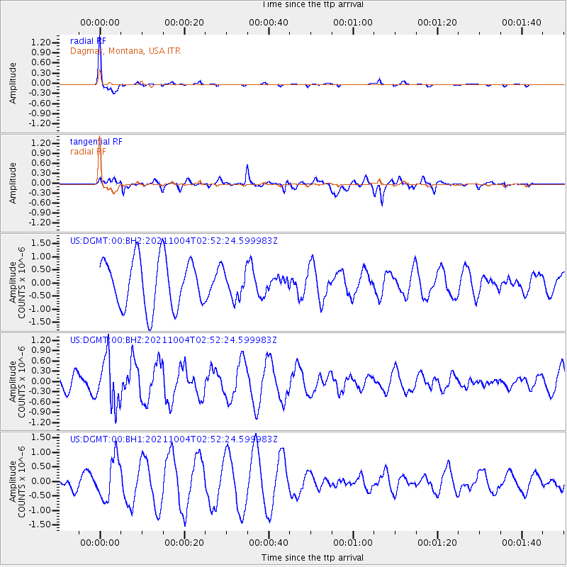
Signal To Noise
| Channel | StoN | STA | LTA |
| US:DGMT:00:BHZ:20211004T02:52:24.599983Z | 2.9988773 | 6.9116953E-7 | 2.304761E-7 |
| US:DGMT:00:BH1:20211004T02:52:24.599983Z | 2.409024 | 7.265378E-7 | 3.0159012E-7 |
| US:DGMT:00:BH2:20211004T02:52:24.599983Z | 0.559294 | 5.242967E-7 | 9.374259E-7 |
| Arrivals |
| Ps | 8.6 SECOND |
| PpPs | 24 SECOND |
| PsPs/PpSs | 32 SECOND |


