You are here: Home > Network List > IU - Global Seismograph Network (GSN - IRIS/USGS) Stations List
> Station PMG Port Moresby, New Guinea > Earthquake Result Viewer
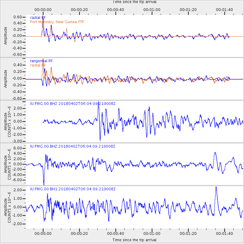
PMG Port Moresby, New Guinea - Earthquake Result Viewer
*The percent match for this event was below the threshold and hence no stack was calculated.
| Earthquake location: |
South Of Fiji Islands |
| Earthquake latitude/longitude: |
-24.9/-176.6 |
| Earthquake time(UTC): |
2018/04/02 (092) 05:57:31 GMT |
| Earthquake Depth: |
84 km |
| Earthquake Magnitude: |
6.1 Mww |
| Earthquake Catalog/Contributor: |
NEIC PDE/us |
|
| Network: |
IU Global Seismograph Network (GSN - IRIS/USGS) |
| Station: |
PMG Port Moresby, New Guinea |
| Lat/Lon: |
9.40 S/147.16 E |
| Elevation: |
90 m |
|
| Distance: |
37.7 deg |
| Az: |
287.668 deg |
| Baz: |
118.724 deg |
| Ray Param: |
$rayparam |
*The percent match for this event was below the threshold and hence was not used in the summary stack. |
|
| Radial Match: |
82.44508 % |
| Radial Bump: |
400 |
| Transverse Match: |
70.53323 % |
| Transverse Bump: |
400 |
| SOD ConfigId: |
2643891 |
| Insert Time: |
2018-04-16 06:00:04.280 +0000 |
| GWidth: |
2.5 |
| Max Bumps: |
400 |
| Tol: |
0.001 |
|
Signal To Noise
| Channel | StoN | STA | LTA |
| IU:PMG:00:BHZ:20180402T06:04:09.219008Z | 17.156431 | 2.764006E-6 | 1.6110613E-7 |
| IU:PMG:00:BH1:20180402T06:04:09.219008Z | 4.4331245 | 8.66204E-7 | 1.9539355E-7 |
| IU:PMG:00:BH2:20180402T06:04:09.219008Z | 8.302789 | 1.4526539E-6 | 1.7495977E-7 |
| Arrivals |
| Ps | |
| PpPs | |
| PsPs/PpSs | |


