You are here: Home > Network List > GT - Global Telemetered Seismograph Network (USAF/USGS) Stations List
> Station BOSA Boshof, South Africa > Earthquake Result Viewer
BOSA Boshof, South Africa - Earthquake Result Viewer
| Earthquake location: |
South Sandwich Islands Region |
| Earthquake latitude/longitude: |
-60.4/-27.5 |
| Earthquake time(UTC): |
2021/10/04 (277) 03:54:06 GMT |
| Earthquake Depth: |
10 km |
| Earthquake Magnitude: |
6.2 mww |
| Earthquake Catalog/Contributor: |
NEIC PDE/us |
|
| Network: |
GT Global Telemetered Seismograph Network (USAF/USGS) |
| Station: |
BOSA Boshof, South Africa |
| Lat/Lon: |
28.61 S/25.26 E |
| Elevation: |
1280 m |
|
| Distance: |
47.3 deg |
| Az: |
72.137 deg |
| Baz: |
212.482 deg |
| Ray Param: |
0.070056595 |
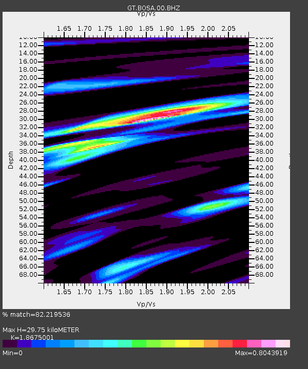
| Estimated Moho Depth: |
29.75 km |
| Estimated Crust Vp/Vs: |
1.87 |
| Assumed Crust Vp: |
6.459 km/s |
| Estimated Crust Vs: |
3.459 km/s |
| Estimated Crust Poisson's Ratio: |
0.30 |
|
| Radial Match: |
82.219536 % |
| Radial Bump: |
387 |
| Transverse Match: |
57.963303 % |
| Transverse Bump: |
400 |
| SOD ConfigId: |
25131211 |
| Insert Time: |
2021-10-18 03:57:18.378 +0000 |
| GWidth: |
2.5 |
| Max Bumps: |
400 |
| Tol: |
0.001 |
|
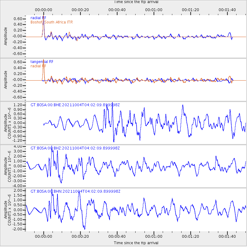
Signal To Noise
| Channel | StoN | STA | LTA |
| GT:BOSA:00:BHZ:20211004T04:02:09.899998Z | 4.397691 | 1.532013E-6 | 3.483676E-7 |
| GT:BOSA:00:BHN:20211004T04:02:09.899998Z | 2.497682 | 8.0864464E-7 | 3.23758E-7 |
| GT:BOSA:00:BHE:20211004T04:02:09.899998Z | 2.9435625 | 5.6882686E-7 | 1.9324436E-7 |
| Arrivals |
| Ps | 4.2 SECOND |
| PpPs | 12 SECOND |
| PsPs/PpSs | 17 SECOND |


