You are here: Home > Network List > GT - Global Telemetered Seismograph Network (USAF/USGS) Stations List
> Station LBTB Lobatse, Botswana, Africa > Earthquake Result Viewer
LBTB Lobatse, Botswana, Africa - Earthquake Result Viewer
| Earthquake location: |
South Sandwich Islands Region |
| Earthquake latitude/longitude: |
-60.4/-27.5 |
| Earthquake time(UTC): |
2021/10/04 (277) 03:54:06 GMT |
| Earthquake Depth: |
10 km |
| Earthquake Magnitude: |
6.2 mww |
| Earthquake Catalog/Contributor: |
NEIC PDE/us |
|
| Network: |
GT Global Telemetered Seismograph Network (USAF/USGS) |
| Station: |
LBTB Lobatse, Botswana, Africa |
| Lat/Lon: |
25.02 S/25.60 E |
| Elevation: |
1128 m |
|
| Distance: |
50.6 deg |
| Az: |
69.984 deg |
| Baz: |
210.914 deg |
| Ray Param: |
0.06798005 |
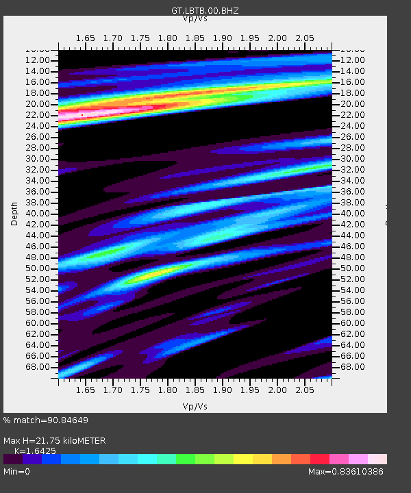
| Estimated Moho Depth: |
21.75 km |
| Estimated Crust Vp/Vs: |
1.64 |
| Assumed Crust Vp: |
6.459 km/s |
| Estimated Crust Vs: |
3.933 km/s |
| Estimated Crust Poisson's Ratio: |
0.21 |
|
| Radial Match: |
90.84649 % |
| Radial Bump: |
393 |
| Transverse Match: |
67.6285 % |
| Transverse Bump: |
400 |
| SOD ConfigId: |
25131211 |
| Insert Time: |
2021-10-18 03:57:22.424 +0000 |
| GWidth: |
2.5 |
| Max Bumps: |
400 |
| Tol: |
0.001 |
|

Signal To Noise
| Channel | StoN | STA | LTA |
| GT:LBTB:00:BHZ:20211004T04:02:34.474003Z | 5.609202 | 1.6106166E-6 | 2.8713828E-7 |
| GT:LBTB:00:BHN:20211004T04:02:34.474003Z | 3.3823576 | 9.2935954E-7 | 2.747668E-7 |
| GT:LBTB:00:BHE:20211004T04:02:34.474003Z | 2.1112175 | 4.2922167E-7 | 2.033053E-7 |
| Arrivals |
| Ps | 2.3 SECOND |
| PpPs | 8.4 SECOND |
| PsPs/PpSs | 11 SECOND |


