You are here: Home > Network List > GT - Global Telemetered Seismograph Network (USAF/USGS) Stations List
> Station LPAZ La Paz , Bolivia > Earthquake Result Viewer
LPAZ La Paz , Bolivia - Earthquake Result Viewer
| Earthquake location: |
South Sandwich Islands Region |
| Earthquake latitude/longitude: |
-60.4/-27.5 |
| Earthquake time(UTC): |
2021/10/04 (277) 03:54:06 GMT |
| Earthquake Depth: |
10 km |
| Earthquake Magnitude: |
6.2 mww |
| Earthquake Catalog/Contributor: |
NEIC PDE/us |
|
| Network: |
GT Global Telemetered Seismograph Network (USAF/USGS) |
| Station: |
LPAZ La Paz , Bolivia |
| Lat/Lon: |
16.17 S/68.08 W |
| Elevation: |
4817 m |
|
| Distance: |
53.0 deg |
| Az: |
308.463 deg |
| Baz: |
156.157 deg |
| Ray Param: |
0.06643372 |
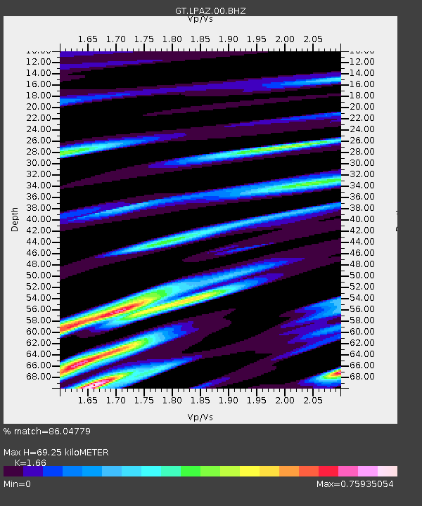
| Estimated Moho Depth: |
69.25 km |
| Estimated Crust Vp/Vs: |
1.66 |
| Assumed Crust Vp: |
6.454 km/s |
| Estimated Crust Vs: |
3.888 km/s |
| Estimated Crust Poisson's Ratio: |
0.22 |
|
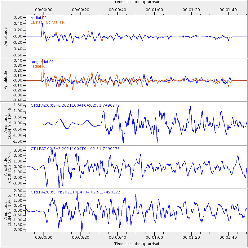
| Radial Match: |
86.04779 % |
| Radial Bump: |
400 |
| Transverse Match: |
72.36423 % |
| Transverse Bump: |
400 |
| SOD ConfigId: |
25131211 |
| Insert Time: |
2021-10-18 03:57:22.424 +0000 |
| GWidth: |
2.5 |
| Max Bumps: |
400 |
| Tol: |
0.001 |
|
Signal To Noise
| Channel | StoN | STA | LTA |
| GT:LPAZ:00:BHZ:20211004T04:02:51.749027Z | 10.533387 | 1.9568067E-6 | 1.8577185E-7 |
| GT:LPAZ:00:BHN:20211004T04:02:51.749027Z | 4.1972766 | 7.3206394E-7 | 1.7441405E-7 |
| GT:LPAZ:00:BHE:20211004T04:02:51.749027Z | 3.021424 | 5.489003E-7 | 1.8166939E-7 |
| Arrivals |
| Ps | 7.5 SECOND |
| PpPs | 27 SECOND |
| PsPs/PpSs | 34 SECOND |


