You are here: Home > Network List > TA - USArray Transportable Network (new EarthScope stations) Stations List
> Station TUL3 Leonard, OK, USA > Earthquake Result Viewer
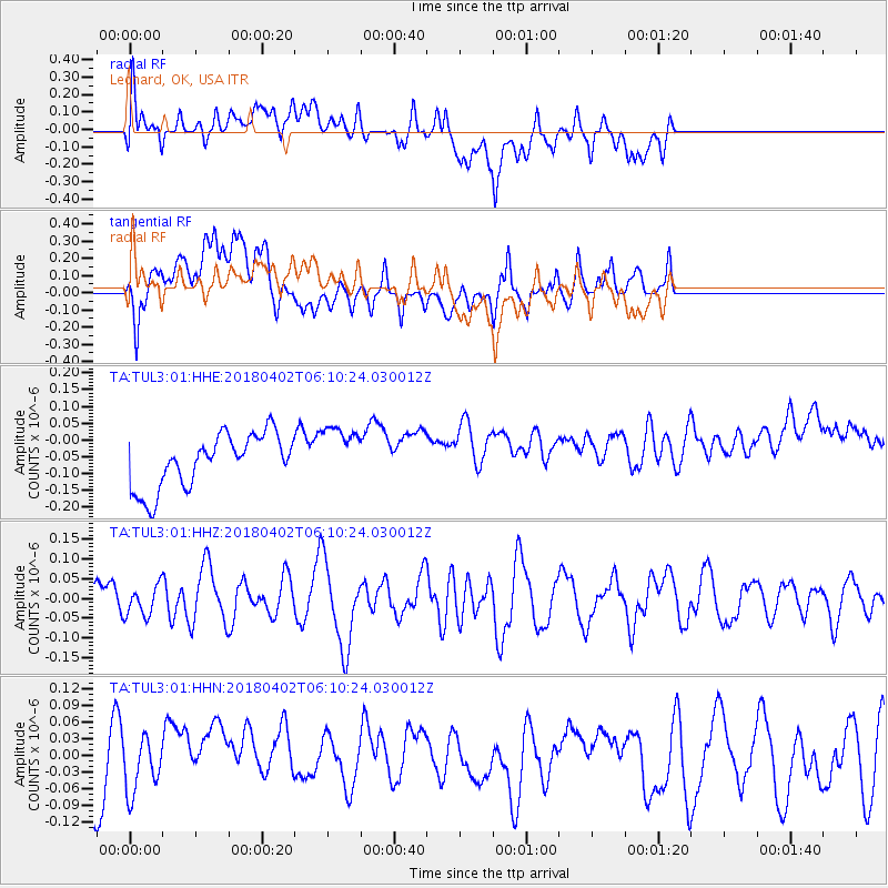
TUL3 Leonard, OK, USA - Earthquake Result Viewer
*The percent match for this event was below the threshold and hence no stack was calculated.
| Earthquake location: |
South Of Fiji Islands |
| Earthquake latitude/longitude: |
-24.9/-176.6 |
| Earthquake time(UTC): |
2018/04/02 (092) 05:57:31 GMT |
| Earthquake Depth: |
84 km |
| Earthquake Magnitude: |
6.1 Mww |
| Earthquake Catalog/Contributor: |
NEIC PDE/us |
|
| Network: |
TA USArray Transportable Network (new EarthScope stations) |
| Station: |
TUL3 Leonard, OK, USA |
| Lat/Lon: |
35.91 N/95.79 W |
| Elevation: |
265 m |
|
| Distance: |
97.3 deg |
| Az: |
53.892 deg |
| Baz: |
244.661 deg |
| Ray Param: |
$rayparam |
*The percent match for this event was below the threshold and hence was not used in the summary stack. |
|
| Radial Match: |
36.598053 % |
| Radial Bump: |
400 |
| Transverse Match: |
49.507317 % |
| Transverse Bump: |
400 |
| SOD ConfigId: |
2643891 |
| Insert Time: |
2018-04-16 06:00:42.230 +0000 |
| GWidth: |
2.5 |
| Max Bumps: |
400 |
| Tol: |
0.001 |
|
Signal To Noise
| Channel | StoN | STA | LTA |
| TA:TUL3:01:HHZ:20180402T06:10:24.030012Z | 0.69629914 | 3.78161E-8 | 5.4310135E-8 |
| TA:TUL3:01:HHN:20180402T06:10:24.030012Z | 0.81169087 | 4.464718E-8 | 5.5005152E-8 |
| TA:TUL3:01:HHE:20180402T06:10:24.030012Z | 1.0736352 | 8.548773E-8 | 7.962455E-8 |
| Arrivals |
| Ps | |
| PpPs | |
| PsPs/PpSs | |


