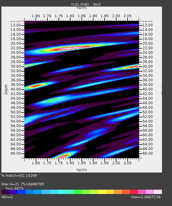
PHID YL.PHID - Earthquake Result Viewer
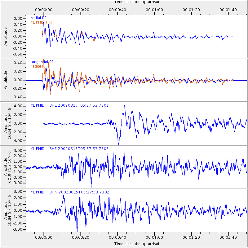
Earthquake location: Sulawesi, Indonesia
Earthquake latitude/longitude: -1.2/121.3
Earthquake time(UTC): 2002/08/15 (227) 05:30:26 GMT
Earthquake Depth: 10 km
Earthquake Magnitude: 5.7 MB, 5.8 MS, 6.2 MW, 6.1 MW
Earthquake Catalog/Contributor: WHDF/NEIC
Network: YL Himalayan Nepal Tibet Experiment
Station: PHID YL.PHID
Lat/Lon: 27.15 N/87.76 E
Elevation: 1176 m
Distance: 42.9 deg
Az: 313.601 deg
Baz: 125.656 deg
Ray Param: 0.07291275
Estimated Moho Depth: 21.75 km
Estimated Crust Vp/Vs: 1.81
Assumed Crust Vp: 6.236 km/s
Estimated Crust Vs: 3.45 km/s
Estimated Crust Poisson's Ratio: 0.28
Radial Match: 82.16299 %
Radial Bump: 400
Transverse Match: 79.09538 %
Transverse Bump: 400
SOD ConfigId: 16820
Insert Time: 2010-02-26 16:03:22.704 +0000
GWidth: 2.5
Max Bumps: 400
Tol: 0.001

Signal To Noise

ChannelStoNSTALTA
YL:PHID: :BHZ:20020815T05:37:53.730Z0.75767761.0436933E-71.3774898E-7
YL:PHID: :BHN:20020815T05:37:53.730Z1.14506661.08473635E-79.473129E-8
YL:PHID: :BHE:20020815T05:37:53.730Z2.2008411.8782684E-78.534321E-8
Arrivals
Ps3.0 SECOND
PpPs9.2 SECOND
PsPs/PpSs12 SECOND