You are here: Home > Network List > AK - Alaska Regional Network Stations List
> Station E22K Anaktuvuk Pass, AK, USA > Earthquake Result Viewer
E22K Anaktuvuk Pass, AK, USA - Earthquake Result Viewer
| Earthquake location: |
Near East Coast Of Honshu, Japan |
| Earthquake latitude/longitude: |
40.1/142.3 |
| Earthquake time(UTC): |
2021/10/05 (278) 17:46:02 GMT |
| Earthquake Depth: |
45 km |
| Earthquake Magnitude: |
5.7 Mww |
| Earthquake Catalog/Contributor: |
NEIC PDE/us |
|
| Network: |
AK Alaska Regional Network |
| Station: |
E22K Anaktuvuk Pass, AK, USA |
| Lat/Lon: |
68.13 N/151.81 W |
| Elevation: |
772 m |
|
| Distance: |
44.6 deg |
| Az: |
29.14 deg |
| Baz: |
265.925 deg |
| Ray Param: |
0.071702346 |
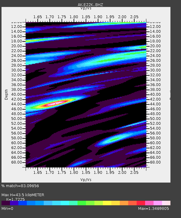
| Estimated Moho Depth: |
43.5 km |
| Estimated Crust Vp/Vs: |
1.72 |
| Assumed Crust Vp: |
6.221 km/s |
| Estimated Crust Vs: |
3.612 km/s |
| Estimated Crust Poisson's Ratio: |
0.25 |
|
| Radial Match: |
83.09656 % |
| Radial Bump: |
400 |
| Transverse Match: |
76.86208 % |
| Transverse Bump: |
400 |
| SOD ConfigId: |
25131211 |
| Insert Time: |
2021-10-19 17:48:50.419 +0000 |
| GWidth: |
2.5 |
| Max Bumps: |
400 |
| Tol: |
0.001 |
|

Signal To Noise
| Channel | StoN | STA | LTA |
| AK:E22K: :BHZ:20211005T17:53:39.560012Z | 12.466483 | 1.1672987E-6 | 9.363497E-8 |
| AK:E22K: :BHN:20211005T17:53:39.560012Z | 2.6523058 | 2.6386812E-7 | 9.94863E-8 |
| AK:E22K: :BHE:20211005T17:53:39.560012Z | 6.443197 | 5.58478E-7 | 8.667716E-8 |
| Arrivals |
| Ps | 5.4 SECOND |
| PpPs | 18 SECOND |
| PsPs/PpSs | 23 SECOND |


