You are here: Home > Network List > AV - Alaska Volcano Observatory Stations List
> Station PLBL Mt. Peulik Volcano, Alaska > Earthquake Result Viewer
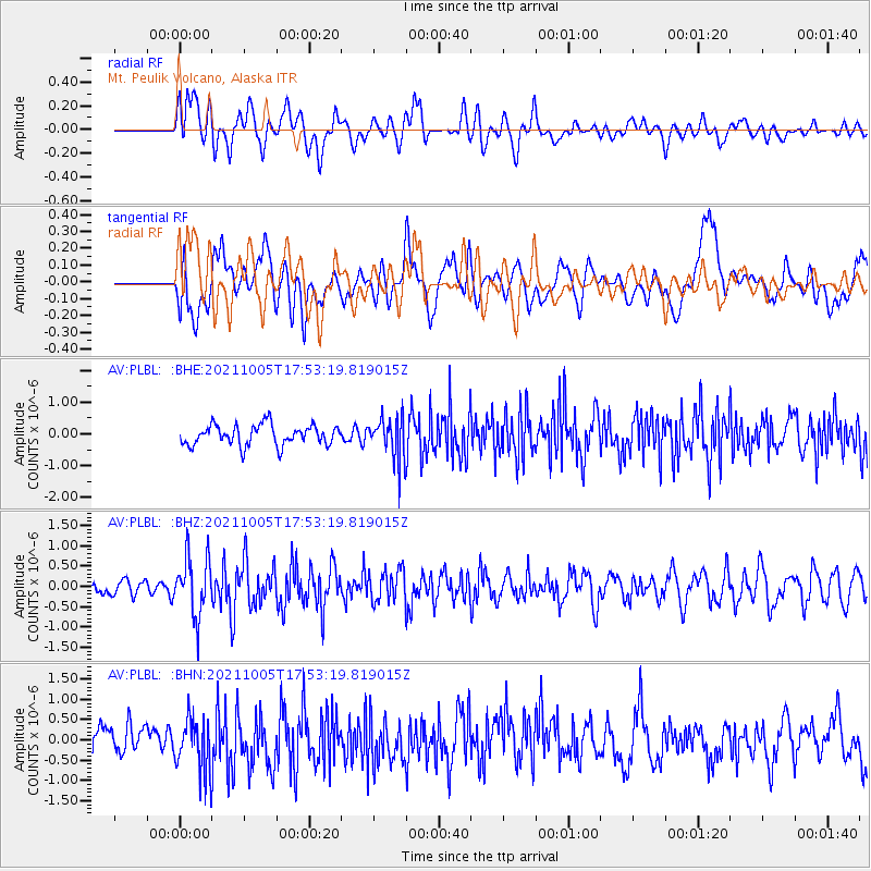
PLBL Mt. Peulik Volcano, Alaska - Earthquake Result Viewer
*The percent match for this event was below the threshold and hence no stack was calculated.
| Earthquake location: |
Near East Coast Of Honshu, Japan |
| Earthquake latitude/longitude: |
40.1/142.3 |
| Earthquake time(UTC): |
2021/10/05 (278) 17:46:02 GMT |
| Earthquake Depth: |
45 km |
| Earthquake Magnitude: |
5.7 Mww |
| Earthquake Catalog/Contributor: |
NEIC PDE/us |
|
| Network: |
AV Alaska Volcano Observatory |
| Station: |
PLBL Mt. Peulik Volcano, Alaska |
| Lat/Lon: |
57.70 N/156.82 W |
| Elevation: |
461 m |
|
| Distance: |
42.2 deg |
| Az: |
44.352 deg |
| Baz: |
272.54 deg |
| Ray Param: |
$rayparam |
*The percent match for this event was below the threshold and hence was not used in the summary stack. |
|
| Radial Match: |
58.891327 % |
| Radial Bump: |
400 |
| Transverse Match: |
46.44977 % |
| Transverse Bump: |
400 |
| SOD ConfigId: |
25131211 |
| Insert Time: |
2021-10-19 17:54:05.445 +0000 |
| GWidth: |
2.5 |
| Max Bumps: |
400 |
| Tol: |
0.001 |
|
Signal To Noise
| Channel | StoN | STA | LTA |
| AV:PLBL: :BHZ:20211005T17:53:19.819015Z | 4.4146543 | 7.386038E-7 | 1.6730728E-7 |
| AV:PLBL: :BHN:20211005T17:53:19.819015Z | 1.7815282 | 6.716031E-7 | 3.769815E-7 |
| AV:PLBL: :BHE:20211005T17:53:19.819015Z | 2.1700065 | 6.9288103E-7 | 3.1929906E-7 |
| Arrivals |
| Ps | |
| PpPs | |
| PsPs/PpSs | |


