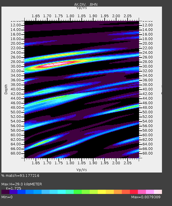
DIV Divide Microwave - Earthquake Result Viewer

Earthquake location: Tonga Islands
Earthquake latitude/longitude: -20.2/-174.1
Earthquake time(UTC): 2006/05/03 (123) 15:26:40 GMT
Earthquake Depth: 55 km
Earthquake Magnitude: 7.2 MB, 7.8 MS, 7.9 MW, 7.9 MW
Earthquake Catalog/Contributor: WHDF/NEIC
Network: AK Alaska Regional Network
Station: DIV Divide Microwave
Lat/Lon: 61.13 N/145.77 W
Elevation: 939 m
Distance: 84.2 deg
Az: 13.394 deg
Baz: 206.638 deg
Ray Param: 0.045562554
Estimated Moho Depth: 29.0 km
Estimated Crust Vp/Vs: 1.73
Assumed Crust Vp: 6.566 km/s
Estimated Crust Vs: 3.806 km/s
Estimated Crust Poisson's Ratio: 0.25
Radial Match: 93.177216 %
Radial Bump: 400
Transverse Match: 93.04013 %
Transverse Bump: 400
SOD ConfigId: 2669
Insert Time: 2010-03-09 13:21:34.363 +0000
GWidth: 2.5
Max Bumps: 400
Tol: 0.001

Signal To Noise

ChannelStoNSTALTA
AK:DIV: :BHN:20060503T15:38:34.540Z7.88643032.9226373E-63.7059064E-7
AK:DIV: :BHE:20060503T15:38:34.540Z1.55267374.4150147E-72.8434917E-7
AK:DIV: :BHZ:20060503T15:38:34.540Z29.2500139.442204E-63.2281022E-7
Arrivals
Ps3.3 SECOND
PpPs12 SECOND
PsPs/PpSs15 SECOND