You are here: Home > Network List > CI - Caltech Regional Seismic Network Stations List
> Station BAR Barrett, Tecate, CA, USA > Earthquake Result Viewer
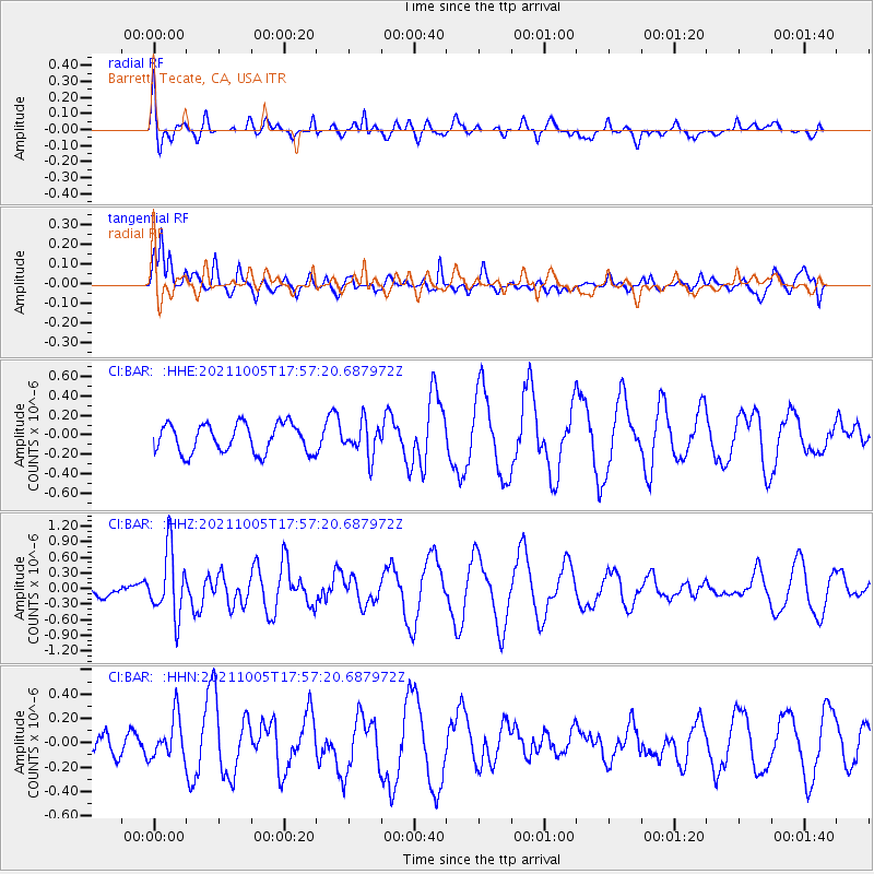
BAR Barrett, Tecate, CA, USA - Earthquake Result Viewer
*The percent match for this event was below the threshold and hence no stack was calculated.
| Earthquake location: |
Near East Coast Of Honshu, Japan |
| Earthquake latitude/longitude: |
40.1/142.3 |
| Earthquake time(UTC): |
2021/10/05 (278) 17:46:02 GMT |
| Earthquake Depth: |
45 km |
| Earthquake Magnitude: |
5.7 Mww |
| Earthquake Catalog/Contributor: |
NEIC PDE/us |
|
| Network: |
CI Caltech Regional Seismic Network |
| Station: |
BAR Barrett, Tecate, CA, USA |
| Lat/Lon: |
32.68 N/116.67 W |
| Elevation: |
521 m |
|
| Distance: |
77.3 deg |
| Az: |
58.047 deg |
| Baz: |
309.467 deg |
| Ray Param: |
$rayparam |
*The percent match for this event was below the threshold and hence was not used in the summary stack. |
|
| Radial Match: |
34.38475 % |
| Radial Bump: |
400 |
| Transverse Match: |
74.36984 % |
| Transverse Bump: |
400 |
| SOD ConfigId: |
25131211 |
| Insert Time: |
2021-10-19 17:57:39.934 +0000 |
| GWidth: |
2.5 |
| Max Bumps: |
400 |
| Tol: |
0.001 |
|
Signal To Noise
| Channel | StoN | STA | LTA |
| CI:BAR: :HHZ:20211005T17:57:20.687972Z | 2.1113296 | 6.3931424E-7 | 3.0280174E-7 |
| CI:BAR: :HHN:20211005T17:57:20.687972Z | 2.1023397 | 1.7226039E-7 | 8.1937465E-8 |
| CI:BAR: :HHE:20211005T17:57:20.687972Z | 1.1469921 | 1.6954293E-7 | 1.4781527E-7 |
| Arrivals |
| Ps | |
| PpPs | |
| PsPs/PpSs | |


