You are here: Home > Network List > CI - Caltech Regional Seismic Network Stations List
> Station MUR Murrieta > Earthquake Result Viewer
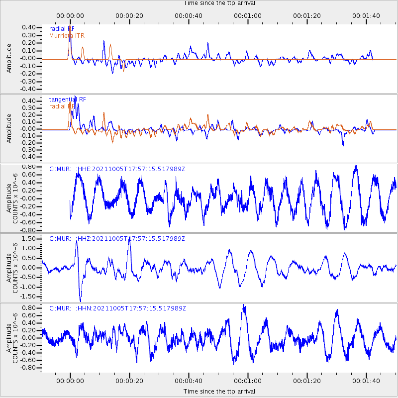
MUR Murrieta - Earthquake Result Viewer
*The percent match for this event was below the threshold and hence no stack was calculated.
| Earthquake location: |
Near East Coast Of Honshu, Japan |
| Earthquake latitude/longitude: |
40.1/142.3 |
| Earthquake time(UTC): |
2021/10/05 (278) 17:46:02 GMT |
| Earthquake Depth: |
45 km |
| Earthquake Magnitude: |
5.7 Mww |
| Earthquake Catalog/Contributor: |
NEIC PDE/us |
|
| Network: |
CI Caltech Regional Seismic Network |
| Station: |
MUR Murrieta |
| Lat/Lon: |
33.60 N/117.20 W |
| Elevation: |
562 m |
|
| Distance: |
76.4 deg |
| Az: |
57.603 deg |
| Baz: |
309.081 deg |
| Ray Param: |
$rayparam |
*The percent match for this event was below the threshold and hence was not used in the summary stack. |
|
| Radial Match: |
58.395348 % |
| Radial Bump: |
400 |
| Transverse Match: |
78.29247 % |
| Transverse Bump: |
297 |
| SOD ConfigId: |
25131211 |
| Insert Time: |
2021-10-19 17:58:21.631 +0000 |
| GWidth: |
2.5 |
| Max Bumps: |
400 |
| Tol: |
0.001 |
|
Signal To Noise
| Channel | StoN | STA | LTA |
| CI:MUR: :HHZ:20211005T17:57:15.517989Z | 3.4057372 | 7.9020896E-7 | 2.3202288E-7 |
| CI:MUR: :HHN:20211005T17:57:15.517989Z | 0.983793 | 2.6498043E-7 | 2.6934572E-7 |
| CI:MUR: :HHE:20211005T17:57:15.517989Z | 0.97670317 | 3.157544E-7 | 3.2328595E-7 |
| Arrivals |
| Ps | |
| PpPs | |
| PsPs/PpSs | |


