You are here: Home > Network List > G - GEOSCOPE Stations List
> Station FDF Fort de France, Martinique France > Earthquake Result Viewer
FDF Fort de France, Martinique France - Earthquake Result Viewer
| Earthquake location: |
Southern Bolivia |
| Earthquake latitude/longitude: |
-20.7/-63.0 |
| Earthquake time(UTC): |
2018/04/02 (092) 13:40:34 GMT |
| Earthquake Depth: |
562 km |
| Earthquake Magnitude: |
6.8 Mww |
| Earthquake Catalog/Contributor: |
NEIC PDE/us |
|
| Network: |
G GEOSCOPE |
| Station: |
FDF Fort de France, Martinique France |
| Lat/Lon: |
14.73 N/61.14 W |
| Elevation: |
467 m |
|
| Distance: |
35.2 deg |
| Az: |
3.145 deg |
| Baz: |
183.044 deg |
| Ray Param: |
0.07454134 |
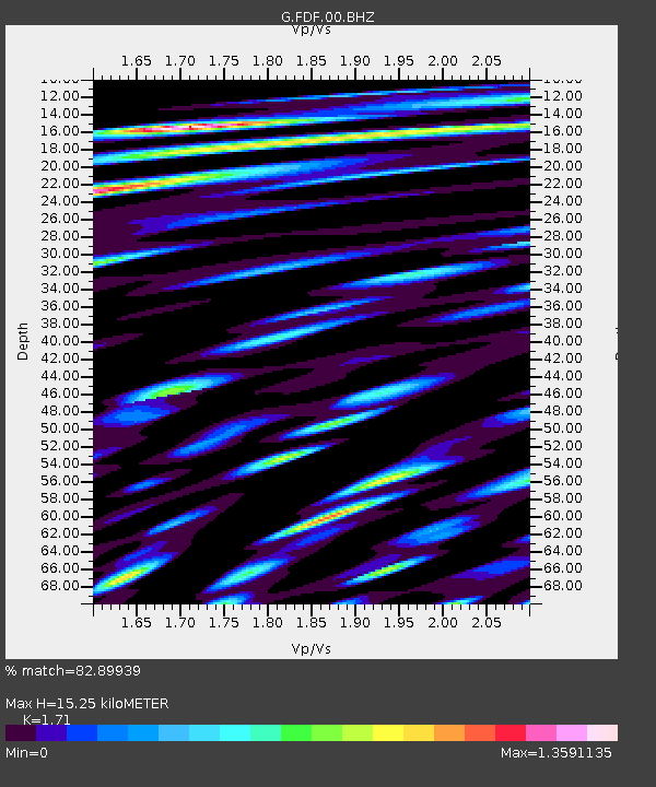
| Estimated Moho Depth: |
15.25 km |
| Estimated Crust Vp/Vs: |
1.71 |
| Assumed Crust Vp: |
5.88 km/s |
| Estimated Crust Vs: |
3.439 km/s |
| Estimated Crust Poisson's Ratio: |
0.24 |
|
| Radial Match: |
82.89939 % |
| Radial Bump: |
400 |
| Transverse Match: |
79.74668 % |
| Transverse Bump: |
400 |
| SOD ConfigId: |
2643891 |
| Insert Time: |
2018-04-16 13:44:38.156 +0000 |
| GWidth: |
2.5 |
| Max Bumps: |
400 |
| Tol: |
0.001 |
|
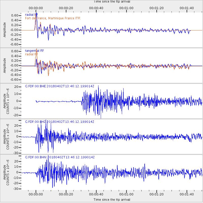
Signal To Noise
| Channel | StoN | STA | LTA |
| G:FDF:00:BHZ:20180402T13:46:12.199014Z | 39.29033 | 1.0362306E-5 | 2.637368E-7 |
| G:FDF:00:BHN:20180402T13:46:12.199014Z | 20.392138 | 5.7534075E-6 | 2.821385E-7 |
| G:FDF:00:BHE:20180402T13:46:12.199014Z | 21.046337 | 7.0559145E-6 | 3.352562E-7 |
| Arrivals |
| Ps | 2.0 SECOND |
| PpPs | 6.6 SECOND |
| PsPs/PpSs | 8.6 SECOND |


