You are here: Home > Network List > GS - US Geological Survey Networks Stations List
> Station OK051 E0350 and S34600 roads, Ralston OK > Earthquake Result Viewer
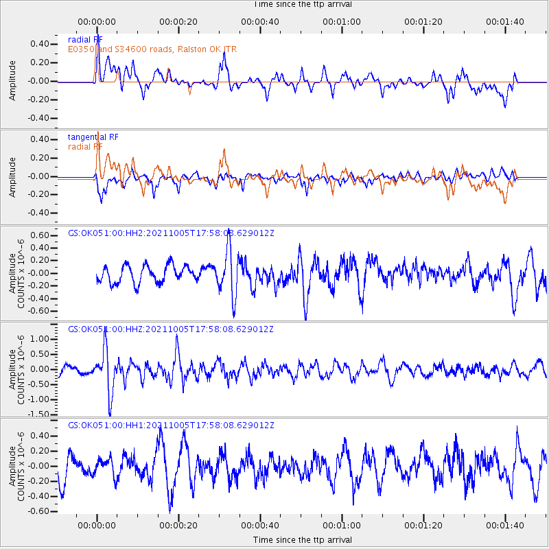
OK051 E0350 and S34600 roads, Ralston OK - Earthquake Result Viewer
*The percent match for this event was below the threshold and hence no stack was calculated.
| Earthquake location: |
Near East Coast Of Honshu, Japan |
| Earthquake latitude/longitude: |
40.1/142.3 |
| Earthquake time(UTC): |
2021/10/05 (278) 17:46:02 GMT |
| Earthquake Depth: |
45 km |
| Earthquake Magnitude: |
5.7 Mww |
| Earthquake Catalog/Contributor: |
NEIC PDE/us |
|
| Network: |
GS US Geological Survey Networks |
| Station: |
OK051 E0350 and S34600 roads, Ralston OK |
| Lat/Lon: |
36.50 N/96.84 W |
| Elevation: |
263 m |
|
| Distance: |
86.4 deg |
| Az: |
43.837 deg |
| Baz: |
318.73 deg |
| Ray Param: |
$rayparam |
*The percent match for this event was below the threshold and hence was not used in the summary stack. |
|
| Radial Match: |
69.16492 % |
| Radial Bump: |
400 |
| Transverse Match: |
63.342415 % |
| Transverse Bump: |
400 |
| SOD ConfigId: |
25131211 |
| Insert Time: |
2021-10-19 18:02:44.977 +0000 |
| GWidth: |
2.5 |
| Max Bumps: |
400 |
| Tol: |
0.001 |
|
Signal To Noise
| Channel | StoN | STA | LTA |
| GS:OK051:00:HHZ:20211005T17:58:08.629012Z | 3.8493917 | 7.315206E-7 | 1.9003537E-7 |
| GS:OK051:00:HH1:20211005T17:58:08.629012Z | 0.7957437 | 1.1809294E-7 | 1.4840575E-7 |
| GS:OK051:00:HH2:20211005T17:58:08.629012Z | 2.7573552 | 3.7144912E-7 | 1.3471211E-7 |
| Arrivals |
| Ps | |
| PpPs | |
| PsPs/PpSs | |


