You are here: Home > Network List > IU - Global Seismograph Network (GSN - IRIS/USGS) Stations List
> Station MAKZ Makanchi, Kazakhstan > Earthquake Result Viewer
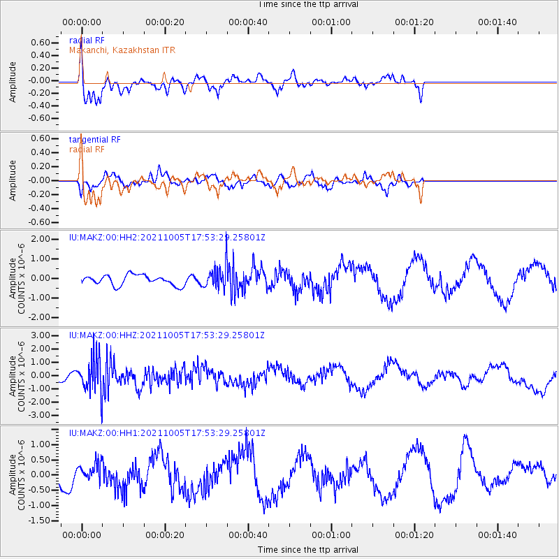
MAKZ Makanchi, Kazakhstan - Earthquake Result Viewer
*The percent match for this event was below the threshold and hence no stack was calculated.
| Earthquake location: |
Near East Coast Of Honshu, Japan |
| Earthquake latitude/longitude: |
40.1/142.3 |
| Earthquake time(UTC): |
2021/10/05 (278) 17:46:02 GMT |
| Earthquake Depth: |
45 km |
| Earthquake Magnitude: |
5.7 Mww |
| Earthquake Catalog/Contributor: |
NEIC PDE/us |
|
| Network: |
IU Global Seismograph Network (GSN - IRIS/USGS) |
| Station: |
MAKZ Makanchi, Kazakhstan |
| Lat/Lon: |
46.81 N/81.98 E |
| Elevation: |
600 m |
|
| Distance: |
43.3 deg |
| Az: |
299.629 deg |
| Baz: |
76.175 deg |
| Ray Param: |
$rayparam |
*The percent match for this event was below the threshold and hence was not used in the summary stack. |
|
| Radial Match: |
78.75351 % |
| Radial Bump: |
376 |
| Transverse Match: |
60.31844 % |
| Transverse Bump: |
357 |
| SOD ConfigId: |
25131211 |
| Insert Time: |
2021-10-19 18:04:04.600 +0000 |
| GWidth: |
2.5 |
| Max Bumps: |
400 |
| Tol: |
0.001 |
|
Signal To Noise
| Channel | StoN | STA | LTA |
| IU:MAKZ:00:HHZ:20211005T17:53:29.25801Z | 4.971482 | 1.2832236E-6 | 2.5811693E-7 |
| IU:MAKZ:00:HH1:20211005T17:53:29.25801Z | 0.6537161 | 2.5536278E-7 | 3.9063252E-7 |
| IU:MAKZ:00:HH2:20211005T17:53:29.25801Z | 2.2862828 | 5.923826E-7 | 2.5910293E-7 |
| Arrivals |
| Ps | |
| PpPs | |
| PsPs/PpSs | |


