You are here: Home > Network List > IW - Intermountain West Stations List
> Station IMW Indian Meadow, Wyoming, USA > Earthquake Result Viewer
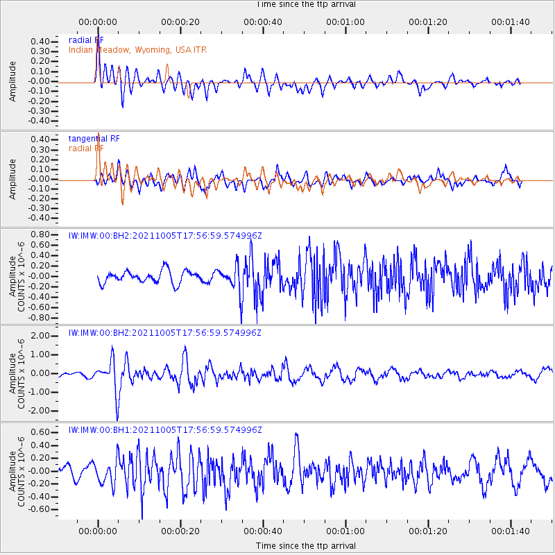
IMW Indian Meadow, Wyoming, USA - Earthquake Result Viewer
*The percent match for this event was below the threshold and hence no stack was calculated.
| Earthquake location: |
Near East Coast Of Honshu, Japan |
| Earthquake latitude/longitude: |
40.1/142.3 |
| Earthquake time(UTC): |
2021/10/05 (278) 17:46:02 GMT |
| Earthquake Depth: |
45 km |
| Earthquake Magnitude: |
5.7 Mww |
| Earthquake Catalog/Contributor: |
NEIC PDE/us |
|
| Network: |
IW Intermountain West |
| Station: |
IMW Indian Meadow, Wyoming, USA |
| Lat/Lon: |
43.90 N/110.94 W |
| Elevation: |
2646 m |
|
| Distance: |
73.6 deg |
| Az: |
46.175 deg |
| Baz: |
310.024 deg |
| Ray Param: |
$rayparam |
*The percent match for this event was below the threshold and hence was not used in the summary stack. |
|
| Radial Match: |
66.149315 % |
| Radial Bump: |
400 |
| Transverse Match: |
72.05907 % |
| Transverse Bump: |
400 |
| SOD ConfigId: |
25131211 |
| Insert Time: |
2021-10-19 18:04:15.130 +0000 |
| GWidth: |
2.5 |
| Max Bumps: |
400 |
| Tol: |
0.001 |
|
Signal To Noise
| Channel | StoN | STA | LTA |
| IW:IMW:00:BHZ:20211005T17:56:59.574996Z | 5.2705 | 8.457674E-7 | 1.6047194E-7 |
| IW:IMW:00:BH1:20211005T17:56:59.574996Z | 1.3814987 | 1.8245792E-7 | 1.3207246E-7 |
| IW:IMW:00:BH2:20211005T17:56:59.574996Z | 2.1073003 | 2.439971E-7 | 1.1578659E-7 |
| Arrivals |
| Ps | |
| PpPs | |
| PsPs/PpSs | |


