You are here: Home > Network List > IW - Intermountain West Stations List
> Station MOOW Moose Ponds, Wyoming, USA > Earthquake Result Viewer
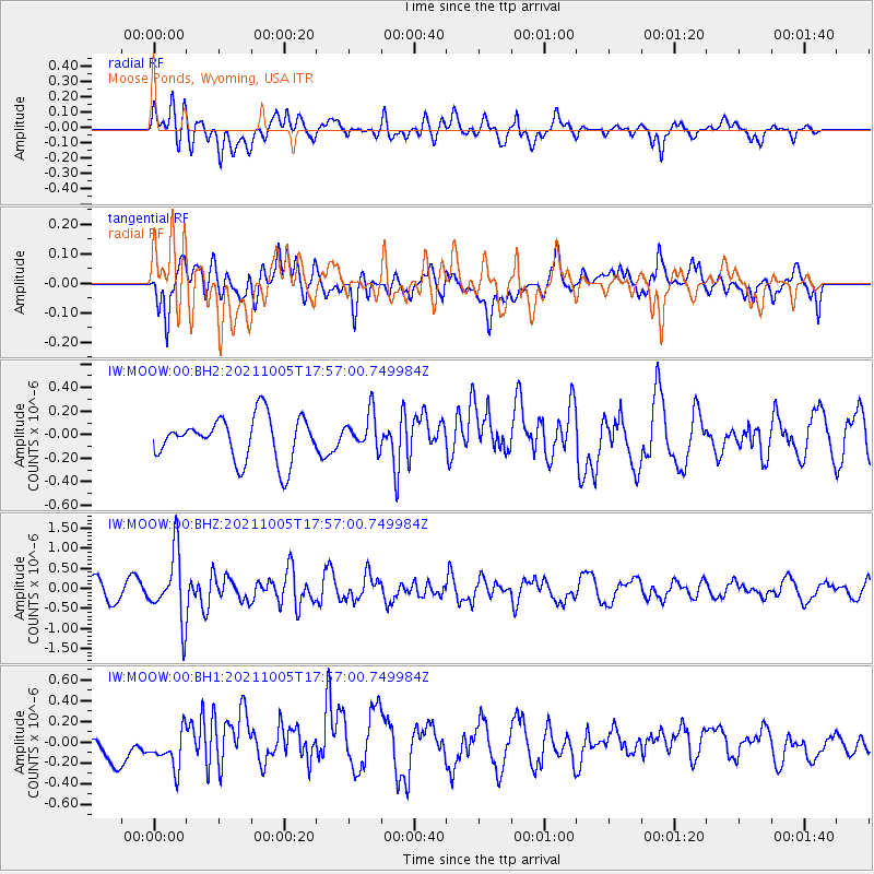
MOOW Moose Ponds, Wyoming, USA - Earthquake Result Viewer
*The percent match for this event was below the threshold and hence no stack was calculated.
| Earthquake location: |
Near East Coast Of Honshu, Japan |
| Earthquake latitude/longitude: |
40.1/142.3 |
| Earthquake time(UTC): |
2021/10/05 (278) 17:46:02 GMT |
| Earthquake Depth: |
45 km |
| Earthquake Magnitude: |
5.7 Mww |
| Earthquake Catalog/Contributor: |
NEIC PDE/us |
|
| Network: |
IW Intermountain West |
| Station: |
MOOW Moose Ponds, Wyoming, USA |
| Lat/Lon: |
43.75 N/110.74 W |
| Elevation: |
2128 m |
|
| Distance: |
73.8 deg |
| Az: |
46.198 deg |
| Baz: |
310.165 deg |
| Ray Param: |
$rayparam |
*The percent match for this event was below the threshold and hence was not used in the summary stack. |
|
| Radial Match: |
59.33861 % |
| Radial Bump: |
400 |
| Transverse Match: |
44.187088 % |
| Transverse Bump: |
400 |
| SOD ConfigId: |
25131211 |
| Insert Time: |
2021-10-19 18:04:19.610 +0000 |
| GWidth: |
2.5 |
| Max Bumps: |
400 |
| Tol: |
0.001 |
|
Signal To Noise
| Channel | StoN | STA | LTA |
| IW:MOOW:00:BHZ:20211005T17:57:00.749984Z | 4.3344593 | 8.431248E-7 | 1.9451672E-7 |
| IW:MOOW:00:BH1:20211005T17:57:00.749984Z | 1.1888628 | 1.6882923E-7 | 1.4200901E-7 |
| IW:MOOW:00:BH2:20211005T17:57:00.749984Z | 0.8344305 | 1.5462577E-7 | 1.8530694E-7 |
| Arrivals |
| Ps | |
| PpPs | |
| PsPs/PpSs | |


