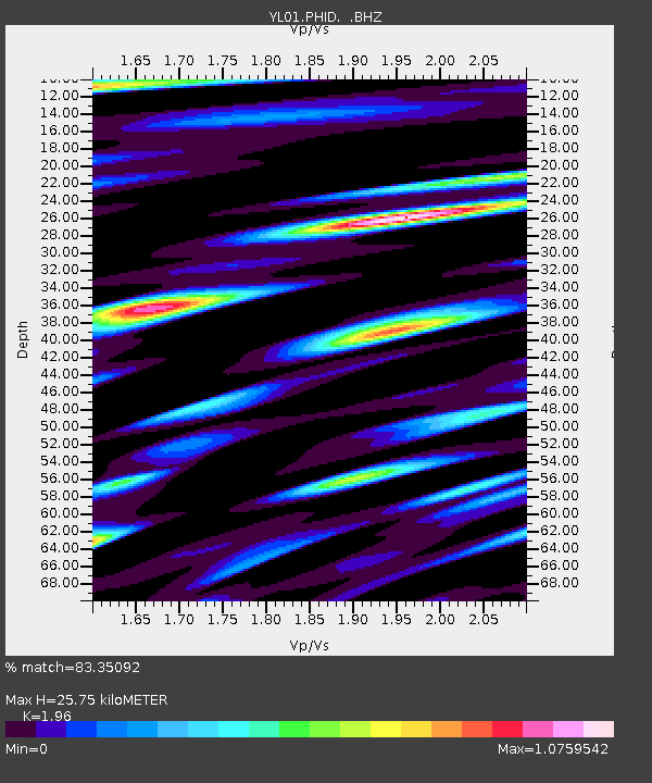
PHID YL.PHID - Earthquake Result Viewer
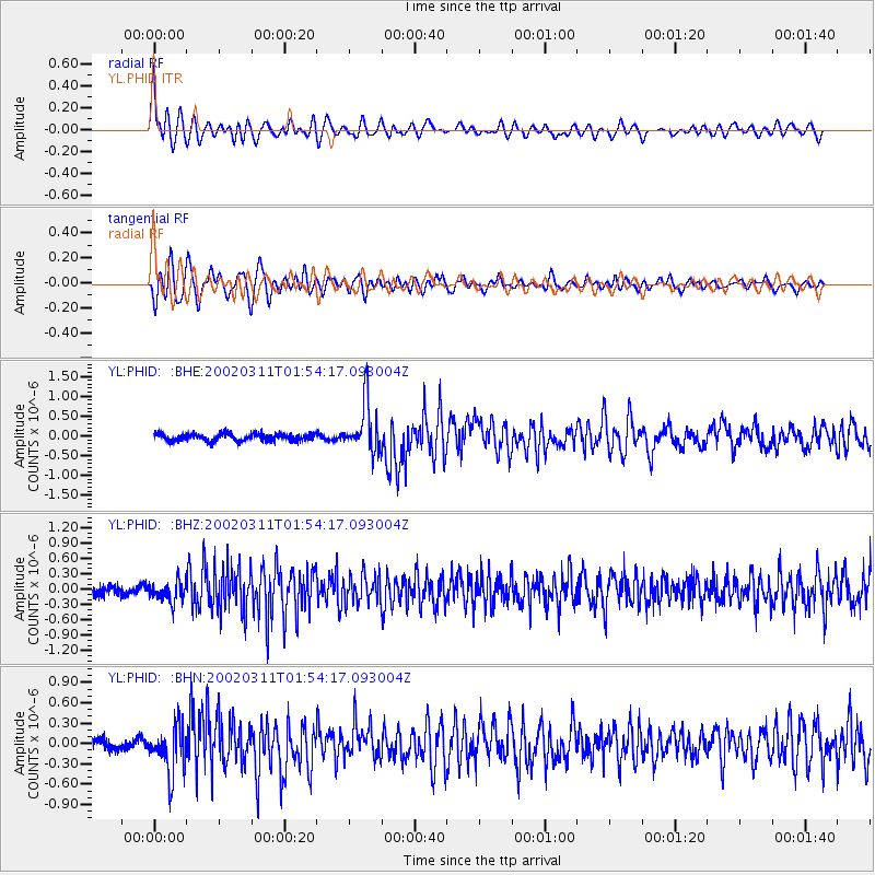
Earthquake location: Southeast Of Honshu, Japan
Earthquake latitude/longitude: 30.6/141.6
Earthquake time(UTC): 2002/03/11 (070) 01:46:20 GMT
Earthquake Depth: 33 km
Earthquake Magnitude: 5.9 MB, 5.6 MS, 5.8 MW, 5.7 MW
Earthquake Catalog/Contributor: WHDF/NEIC
Network: YL Himalayan Nepal Tibet Experiment
Station: PHID YL.PHID
Lat/Lon: 27.15 N/87.76 E
Elevation: 1176 m
Distance: 46.9 deg
Az: 279.849 deg
Baz: 72.441 deg
Ray Param: 0.07030042
Estimated Moho Depth: 25.75 km
Estimated Crust Vp/Vs: 1.96
Assumed Crust Vp: 6.236 km/s
Estimated Crust Vs: 3.182 km/s
Estimated Crust Poisson's Ratio: 0.32
Radial Match: 83.35092 %
Radial Bump: 400
Transverse Match: 73.83021 %
Transverse Bump: 400
SOD ConfigId: 16820
Insert Time: 2010-02-26 16:03:39.533 +0000
GWidth: 2.5
Max Bumps: 400
Tol: 0.001

Signal To Noise

ChannelStoNSTALTA
YL:PHID: :BHZ:20020311T01:54:17.093004Z2.28926871.9425983E-78.4856715E-8
YL:PHID: :BHN:20020311T01:54:17.093004Z5.44592333.4864163E-76.401883E-8
YL:PHID: :BHE:20020311T01:54:17.093004Z7.07675846.2827735E-78.878039E-8
Arrivals
Ps4.2 SECOND
PpPs12 SECOND
PsPs/PpSs16 SECOND