You are here: Home > Network List > GS - US Geological Survey Networks Stations List
> Station KAN13 Rinehart Farm > Earthquake Result Viewer
KAN13 Rinehart Farm - Earthquake Result Viewer
*The percent match for this event was below the threshold and hence no stack was calculated.
| Earthquake location: |
Southern Bolivia |
| Earthquake latitude/longitude: |
-20.7/-63.0 |
| Earthquake time(UTC): |
2018/04/02 (092) 13:40:34 GMT |
| Earthquake Depth: |
562 km |
| Earthquake Magnitude: |
6.8 Mww |
| Earthquake Catalog/Contributor: |
NEIC PDE/us |
|
| Network: |
GS US Geological Survey Networks |
| Station: |
KAN13 Rinehart Farm |
| Lat/Lon: |
37.01 N/97.48 W |
| Elevation: |
340 m |
|
| Distance: |
65.9 deg |
| Az: |
330.26 deg |
| Baz: |
144.521 deg |
| Ray Param: |
$rayparam |
*The percent match for this event was below the threshold and hence was not used in the summary stack. |
|
| Radial Match: |
39.450794 % |
| Radial Bump: |
346 |
| Transverse Match: |
51.838425 % |
| Transverse Bump: |
400 |
| SOD ConfigId: |
2643891 |
| Insert Time: |
2018-04-16 13:45:26.742 +0000 |
| GWidth: |
2.5 |
| Max Bumps: |
400 |
| Tol: |
0.001 |
|
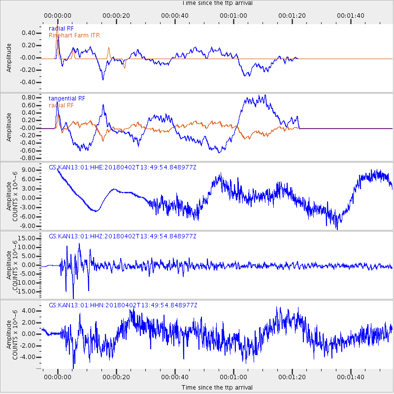
Signal To Noise
| Channel | StoN | STA | LTA |
| GS:KAN13:01:HHZ:20180402T13:49:54.848977Z | 16.107756 | 3.6201775E-6 | 2.2474748E-7 |
| GS:KAN13:01:HHN:20180402T13:49:54.848977Z | 0.93075925 | 1.0119386E-6 | 1.0872184E-6 |
| GS:KAN13:01:HHE:20180402T13:49:54.848977Z | 0.90878356 | 2.9950124E-6 | 3.295628E-6 |
| Arrivals |
| Ps | |
| PpPs | |
| PsPs/PpSs | |


