You are here: Home > Network List > US - United States National Seismic Network Stations List
> Station AMTX Amarillo, Texas, USA > Earthquake Result Viewer
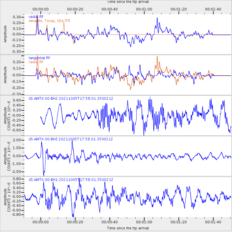
AMTX Amarillo, Texas, USA - Earthquake Result Viewer
*The percent match for this event was below the threshold and hence no stack was calculated.
| Earthquake location: |
Near East Coast Of Honshu, Japan |
| Earthquake latitude/longitude: |
40.1/142.3 |
| Earthquake time(UTC): |
2021/10/05 (278) 17:46:02 GMT |
| Earthquake Depth: |
45 km |
| Earthquake Magnitude: |
5.7 Mww |
| Earthquake Catalog/Contributor: |
NEIC PDE/us |
|
| Network: |
US United States National Seismic Network |
| Station: |
AMTX Amarillo, Texas, USA |
| Lat/Lon: |
34.53 N/101.41 W |
| Elevation: |
1010 m |
|
| Distance: |
85.4 deg |
| Az: |
47.929 deg |
| Baz: |
316.377 deg |
| Ray Param: |
$rayparam |
*The percent match for this event was below the threshold and hence was not used in the summary stack. |
|
| Radial Match: |
48.273712 % |
| Radial Bump: |
400 |
| Transverse Match: |
52.993206 % |
| Transverse Bump: |
334 |
| SOD ConfigId: |
25131211 |
| Insert Time: |
2021-10-19 18:16:21.767 +0000 |
| GWidth: |
2.5 |
| Max Bumps: |
400 |
| Tol: |
0.001 |
|
Signal To Noise
| Channel | StoN | STA | LTA |
| US:AMTX:00:BHZ:20211005T17:58:01.350021Z | 4.350768 | 1.106544E-6 | 2.5433303E-7 |
| US:AMTX:00:BH1:20211005T17:58:01.350021Z | 2.5723624 | 2.9515616E-7 | 1.14741276E-7 |
| US:AMTX:00:BH2:20211005T17:58:01.350021Z | 1.139631 | 2.4237897E-7 | 2.1268197E-7 |
| Arrivals |
| Ps | |
| PpPs | |
| PsPs/PpSs | |


