You are here: Home > Network List > US - United States National Seismic Network Stations List
> Station TPNV Topopah Spring, Nevada, USA > Earthquake Result Viewer
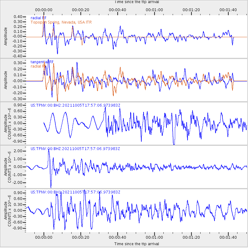
TPNV Topopah Spring, Nevada, USA - Earthquake Result Viewer
*The percent match for this event was below the threshold and hence no stack was calculated.
| Earthquake location: |
Near East Coast Of Honshu, Japan |
| Earthquake latitude/longitude: |
40.1/142.3 |
| Earthquake time(UTC): |
2021/10/05 (278) 17:46:02 GMT |
| Earthquake Depth: |
45 km |
| Earthquake Magnitude: |
5.7 Mww |
| Earthquake Catalog/Contributor: |
NEIC PDE/us |
|
| Network: |
US United States National Seismic Network |
| Station: |
TPNV Topopah Spring, Nevada, USA |
| Lat/Lon: |
36.95 N/116.25 W |
| Elevation: |
1600 m |
|
| Distance: |
74.9 deg |
| Az: |
54.418 deg |
| Baz: |
308.833 deg |
| Ray Param: |
$rayparam |
*The percent match for this event was below the threshold and hence was not used in the summary stack. |
|
| Radial Match: |
71.063324 % |
| Radial Bump: |
400 |
| Transverse Match: |
80.17046 % |
| Transverse Bump: |
400 |
| SOD ConfigId: |
25131211 |
| Insert Time: |
2021-10-19 18:17:11.790 +0000 |
| GWidth: |
2.5 |
| Max Bumps: |
400 |
| Tol: |
0.001 |
|
Signal To Noise
| Channel | StoN | STA | LTA |
| US:TPNV:00:BHZ:20211005T17:57:06.973983Z | 5.632571 | 1.0457304E-6 | 1.8565774E-7 |
| US:TPNV:00:BH1:20211005T17:57:06.973983Z | 1.3141799 | 1.796899E-7 | 1.3673159E-7 |
| US:TPNV:00:BH2:20211005T17:57:06.973983Z | 1.2163773 | 3.691914E-7 | 3.0351717E-7 |
| Arrivals |
| Ps | |
| PpPs | |
| PsPs/PpSs | |


