You are here: Home > Network List > UW - Pacific Northwest Regional Seismic Network Stations List
> Station LTY Liberty (broad-band) > Earthquake Result Viewer
LTY Liberty (broad-band) - Earthquake Result Viewer
*The percent match for this event was below the threshold and hence no stack was calculated.
| Earthquake location: |
Near East Coast Of Honshu, Japan |
| Earthquake latitude/longitude: |
40.1/142.3 |
| Earthquake time(UTC): |
2021/10/05 (278) 17:46:02 GMT |
| Earthquake Depth: |
45 km |
| Earthquake Magnitude: |
5.7 Mww |
| Earthquake Catalog/Contributor: |
NEIC PDE/us |
|
| Network: |
UW Pacific Northwest Regional Seismic Network |
| Station: |
LTY Liberty (broad-band) |
| Lat/Lon: |
47.26 N/120.66 W |
| Elevation: |
970 m |
|
| Distance: |
66.1 deg |
| Az: |
47.676 deg |
| Baz: |
303.609 deg |
| Ray Param: |
$rayparam |
*The percent match for this event was below the threshold and hence was not used in the summary stack. |
|
| Radial Match: |
66.55106 % |
| Radial Bump: |
400 |
| Transverse Match: |
32.353554 % |
| Transverse Bump: |
284 |
| SOD ConfigId: |
25131211 |
| Insert Time: |
2021-10-19 18:18:14.994 +0000 |
| GWidth: |
2.5 |
| Max Bumps: |
400 |
| Tol: |
0.001 |
|
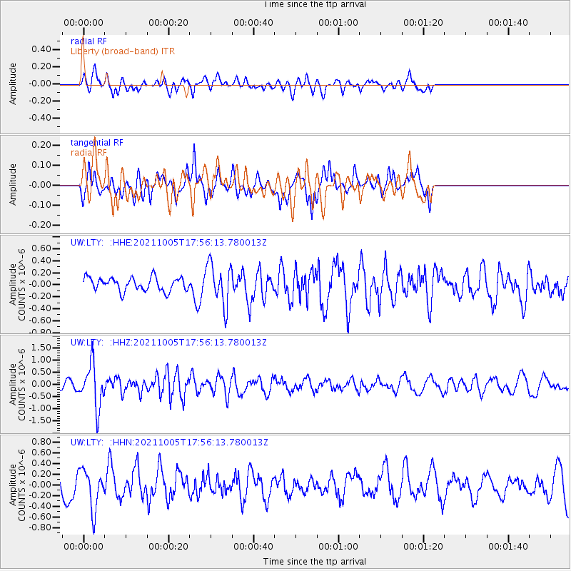
Signal To Noise
| Channel | StoN | STA | LTA |
| UW:LTY: :HHZ:20211005T17:56:13.780013Z | 4.847763 | 9.097231E-7 | 1.8765833E-7 |
| UW:LTY: :HHN:20211005T17:56:13.780013Z | 2.126764 | 3.7574043E-7 | 1.7667236E-7 |
| UW:LTY: :HHE:20211005T17:56:13.780013Z | 3.1422842 | 3.4678135E-7 | 1.10359636E-7 |
| Arrivals |
| Ps | |
| PpPs | |
| PsPs/PpSs | |


