You are here: Home > Network List > IW - Intermountain West Stations List
> Station IMW Indian Meadow, Wyoming, USA > Earthquake Result Viewer
IMW Indian Meadow, Wyoming, USA - Earthquake Result Viewer
| Earthquake location: |
Southern Bolivia |
| Earthquake latitude/longitude: |
-20.7/-63.0 |
| Earthquake time(UTC): |
2018/04/02 (092) 13:40:34 GMT |
| Earthquake Depth: |
562 km |
| Earthquake Magnitude: |
6.8 Mww |
| Earthquake Catalog/Contributor: |
NEIC PDE/us |
|
| Network: |
IW Intermountain West |
| Station: |
IMW Indian Meadow, Wyoming, USA |
| Lat/Lon: |
43.90 N/110.94 W |
| Elevation: |
2646 m |
|
| Distance: |
77.8 deg |
| Az: |
326.703 deg |
| Baz: |
134.667 deg |
| Ray Param: |
0.04833102 |
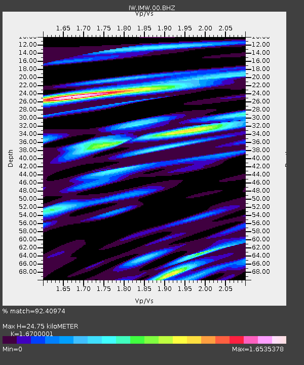
| Estimated Moho Depth: |
24.75 km |
| Estimated Crust Vp/Vs: |
1.67 |
| Assumed Crust Vp: |
6.207 km/s |
| Estimated Crust Vs: |
3.717 km/s |
| Estimated Crust Poisson's Ratio: |
0.22 |
|
| Radial Match: |
92.40974 % |
| Radial Bump: |
400 |
| Transverse Match: |
91.25735 % |
| Transverse Bump: |
400 |
| SOD ConfigId: |
2643891 |
| Insert Time: |
2018-04-16 13:46:34.605 +0000 |
| GWidth: |
2.5 |
| Max Bumps: |
400 |
| Tol: |
0.001 |
|

Signal To Noise
| Channel | StoN | STA | LTA |
| IW:IMW:00:BHZ:20180402T13:51:03.454995Z | 19.70674 | 3.4256238E-6 | 1.7383007E-7 |
| IW:IMW:00:BH1:20180402T13:51:03.454995Z | 9.001547 | 1.8718752E-6 | 2.079504E-7 |
| IW:IMW:00:BH2:20180402T13:51:03.454995Z | 6.52522 | 1.3135552E-6 | 2.0130436E-7 |
| Arrivals |
| Ps | 2.7 SECOND |
| PpPs | 10 SECOND |
| PsPs/PpSs | 13 SECOND |


