You are here: Home > Network List > IU - Global Seismograph Network (GSN - IRIS/USGS) Stations List
> Station JOHN Johnston Island, USA > Earthquake Result Viewer
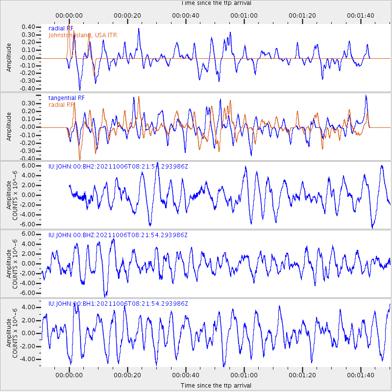
JOHN Johnston Island, USA - Earthquake Result Viewer
*The percent match for this event was below the threshold and hence no stack was calculated.
| Earthquake location: |
Kyushu, Japan |
| Earthquake latitude/longitude: |
31.2/131.4 |
| Earthquake time(UTC): |
2021/10/06 (279) 08:12:56 GMT |
| Earthquake Depth: |
44 km |
| Earthquake Magnitude: |
5.5 mww |
| Earthquake Catalog/Contributor: |
NEIC PDE/us |
|
| Network: |
IU Global Seismograph Network (GSN - IRIS/USGS) |
| Station: |
JOHN Johnston Island, USA |
| Lat/Lon: |
16.73 N/169.53 W |
| Elevation: |
2.0 m |
|
| Distance: |
55.3 deg |
| Az: |
90.636 deg |
| Baz: |
296.626 deg |
| Ray Param: |
$rayparam |
*The percent match for this event was below the threshold and hence was not used in the summary stack. |
|
| Radial Match: |
57.232243 % |
| Radial Bump: |
400 |
| Transverse Match: |
55.919373 % |
| Transverse Bump: |
400 |
| SOD ConfigId: |
25131211 |
| Insert Time: |
2021-10-20 08:22:22.222 +0000 |
| GWidth: |
2.5 |
| Max Bumps: |
400 |
| Tol: |
0.001 |
|
Signal To Noise
| Channel | StoN | STA | LTA |
| IU:JOHN:00:BHZ:20211006T08:21:54.293986Z | 1.220567 | 2.5389386E-6 | 2.0801306E-6 |
| IU:JOHN:00:BH1:20211006T08:21:54.293986Z | 2.3829772 | 3.3413598E-6 | 1.4021788E-6 |
| IU:JOHN:00:BH2:20211006T08:21:54.293986Z | 1.8229587 | 3.080271E-6 | 1.6897097E-6 |
| Arrivals |
| Ps | |
| PpPs | |
| PsPs/PpSs | |


