You are here: Home > Network List > YL01 - Himalayan Nepal Tibet Experiment Stations List
> Station PHID YL.PHID > Earthquake Result Viewer
PHID YL.PHID - Earthquake Result Viewer
| Earthquake location: |
Southern Greece |
| Earthquake latitude/longitude: |
36.6/24.3 |
| Earthquake time(UTC): |
2002/05/21 (141) 20:53:29 GMT |
| Earthquake Depth: |
97 km |
| Earthquake Magnitude: |
5.4 MB, 5.6 MD |
| Earthquake Catalog/Contributor: |
WHDF/NEIC |
|
| Network: |
YL Himalayan Nepal Tibet Experiment |
| Station: |
PHID YL.PHID |
| Lat/Lon: |
27.15 N/87.76 E |
| Elevation: |
1176 m |
|
| Distance: |
53.9 deg |
| Az: |
80.818 deg |
| Baz: |
296.971 deg |
| Ray Param: |
0.06551551 |
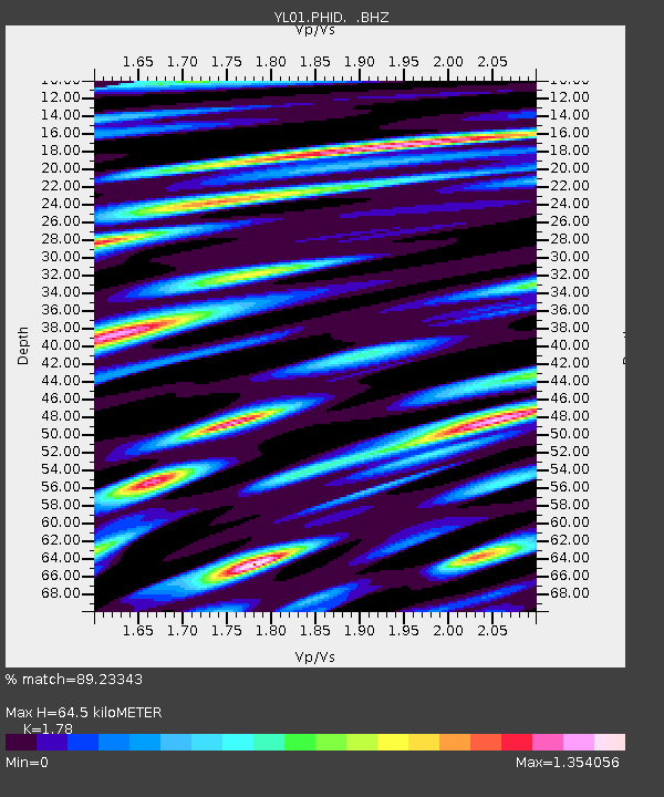
| Estimated Moho Depth: |
64.5 km |
| Estimated Crust Vp/Vs: |
1.78 |
| Assumed Crust Vp: |
6.236 km/s |
| Estimated Crust Vs: |
3.503 km/s |
| Estimated Crust Poisson's Ratio: |
0.27 |
|
| Radial Match: |
89.23343 % |
| Radial Bump: |
400 |
| Transverse Match: |
81.13043 % |
| Transverse Bump: |
400 |
| SOD ConfigId: |
16844 |
| Insert Time: |
2010-02-26 16:03:54.523 +0000 |
| GWidth: |
2.5 |
| Max Bumps: |
400 |
| Tol: |
0.001 |
|
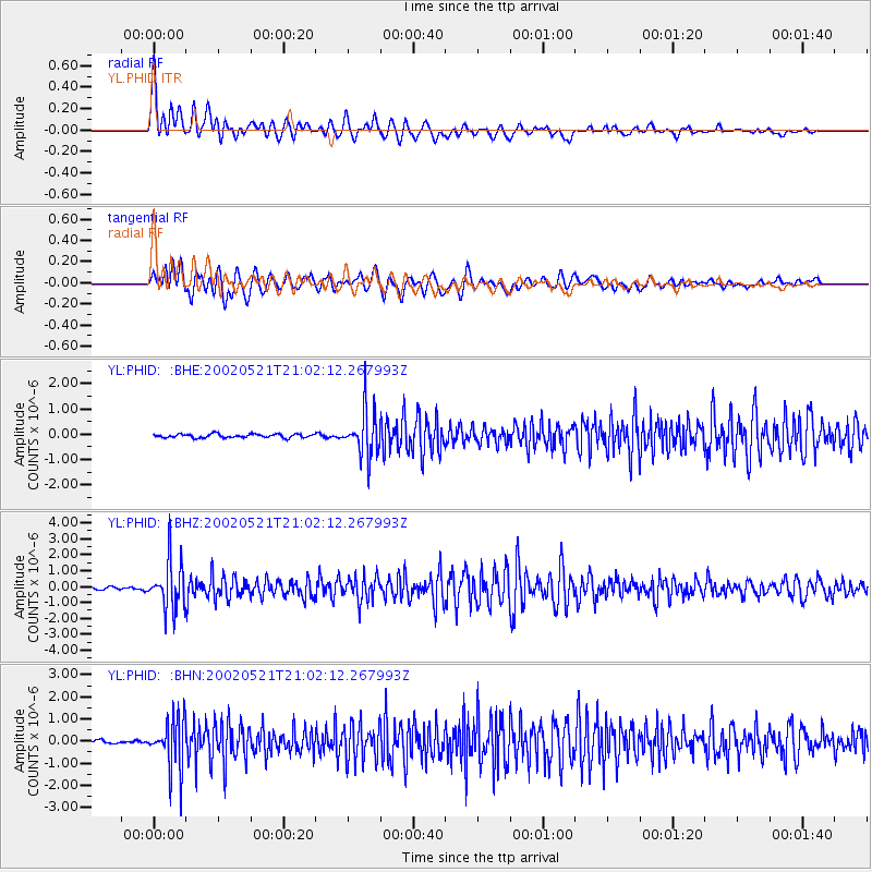
Signal To Noise
| Channel | StoN | STA | LTA |
| YL:PHID: :BHZ:20020521T21:02:12.267993Z | 17.019768 | 1.5098625E-6 | 8.8712284E-8 |
| YL:PHID: :BHN:20020521T21:02:12.267993Z | 15.429248 | 1.1301171E-6 | 7.324512E-8 |
| YL:PHID: :BHE:20020521T21:02:12.267993Z | 11.86994 | 8.69005E-7 | 7.3210565E-8 |
| Arrivals |
| Ps | 8.5 SECOND |
| PpPs | 27 SECOND |
| PsPs/PpSs | 36 SECOND |


