You are here: Home > Network List > AK - Alaska Regional Network Stations List
> Station RC01 Rabbit Creek > Earthquake Result Viewer
RC01 Rabbit Creek - Earthquake Result Viewer
| Earthquake location: |
Tonga Islands |
| Earthquake latitude/longitude: |
-16.8/-174.2 |
| Earthquake time(UTC): |
2004/01/25 (025) 11:43:11 GMT |
| Earthquake Depth: |
130 km |
| Earthquake Magnitude: |
6.4 MB, 6.7 MW, 6.7 MW |
| Earthquake Catalog/Contributor: |
WHDF/NEIC |
|
| Network: |
AK Alaska Regional Network |
| Station: |
RC01 Rabbit Creek |
| Lat/Lon: |
61.09 N/149.74 W |
| Elevation: |
383 m |
|
| Distance: |
80.1 deg |
| Az: |
11.785 deg |
| Baz: |
203.737 deg |
| Ray Param: |
0.04821375 |
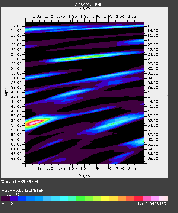
| Estimated Moho Depth: |
52.5 km |
| Estimated Crust Vp/Vs: |
1.64 |
| Assumed Crust Vp: |
6.566 km/s |
| Estimated Crust Vs: |
4.004 km/s |
| Estimated Crust Poisson's Ratio: |
0.20 |
|
| Radial Match: |
89.89794 % |
| Radial Bump: |
361 |
| Transverse Match: |
90.82995 % |
| Transverse Bump: |
366 |
| SOD ConfigId: |
263228 |
| Insert Time: |
2010-03-09 13:25:06.254 +0000 |
| GWidth: |
2.5 |
| Max Bumps: |
400 |
| Tol: |
0.001 |
|

Signal To Noise
| Channel | StoN | STA | LTA |
| AK:RC01: :BHN:20040125T11:54:36.239019Z | 8.492742 | 2.183751E-6 | 2.5713146E-7 |
| AK:RC01: :BHE:20040125T11:54:36.239019Z | 7.751371 | 1.8305245E-6 | 2.3615493E-7 |
| AK:RC01: :BHZ:20040125T11:54:36.239019Z | 48.54974 | 9.075207E-6 | 1.8692597E-7 |
| Arrivals |
| Ps | 5.3 SECOND |
| PpPs | 20 SECOND |
| PsPs/PpSs | 26 SECOND |


