You are here: Home > Network List > YL01 - Himalayan Nepal Tibet Experiment Stations List
> Station PHID YL.PHID > Earthquake Result Viewer
PHID YL.PHID - Earthquake Result Viewer
| Earthquake location: |
Bonin Islands, Japan Region |
| Earthquake latitude/longitude: |
27.6/139.8 |
| Earthquake time(UTC): |
2002/06/03 (154) 09:15:00 GMT |
| Earthquake Depth: |
489 km |
| Earthquake Magnitude: |
5.0 MB, 5.9 MW, 5.9 MW |
| Earthquake Catalog/Contributor: |
WHDF/NEIC |
|
| Network: |
YL Himalayan Nepal Tibet Experiment |
| Station: |
PHID YL.PHID |
| Lat/Lon: |
27.15 N/87.76 E |
| Elevation: |
1176 m |
|
| Distance: |
45.9 deg |
| Az: |
282.097 deg |
| Baz: |
76.953 deg |
| Ray Param: |
0.06872421 |
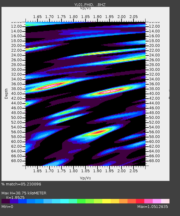
| Estimated Moho Depth: |
38.75 km |
| Estimated Crust Vp/Vs: |
1.95 |
| Assumed Crust Vp: |
6.236 km/s |
| Estimated Crust Vs: |
3.194 km/s |
| Estimated Crust Poisson's Ratio: |
0.32 |
|
| Radial Match: |
85.230896 % |
| Radial Bump: |
400 |
| Transverse Match: |
82.28325 % |
| Transverse Bump: |
400 |
| SOD ConfigId: |
16844 |
| Insert Time: |
2010-02-26 16:03:59.840 +0000 |
| GWidth: |
2.5 |
| Max Bumps: |
400 |
| Tol: |
0.001 |
|
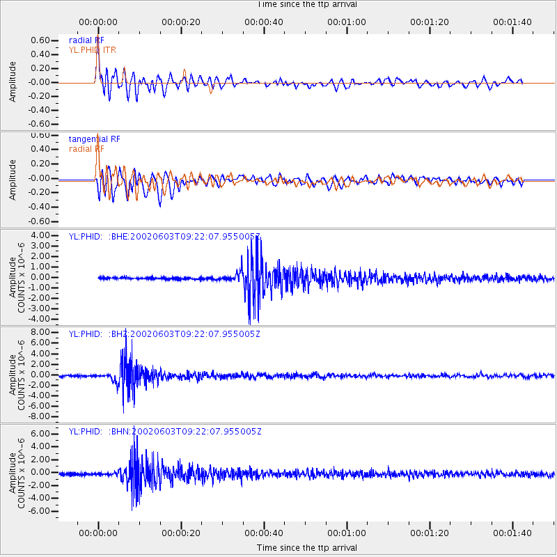
Signal To Noise
| Channel | StoN | STA | LTA |
| YL:PHID: :BHZ:20020603T09:22:07.955005Z | 7.029956 | 7.953756E-7 | 1.1314091E-7 |
| YL:PHID: :BHN:20020603T09:22:07.955005Z | 1.1635742 | 1.6444943E-7 | 1.4133127E-7 |
| YL:PHID: :BHE:20020603T09:22:07.955005Z | 5.8879046 | 4.6267056E-7 | 7.857982E-8 |
| Arrivals |
| Ps | 6.2 SECOND |
| PpPs | 17 SECOND |
| PsPs/PpSs | 24 SECOND |


