You are here: Home > Network List > TX - Texas Seismological Network Stations List
> Station FW16 Waxahatchie > Earthquake Result Viewer
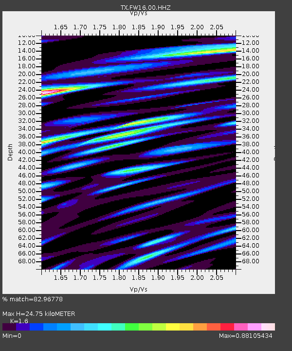
FW16 Waxahatchie - Earthquake Result Viewer
| Earthquake location: |
Southern Bolivia |
| Earthquake latitude/longitude: |
-20.7/-63.0 |
| Earthquake time(UTC): |
2018/04/02 (092) 13:40:34 GMT |
| Earthquake Depth: |
562 km |
| Earthquake Magnitude: |
6.8 Mww |
| Earthquake Catalog/Contributor: |
NEIC PDE/us |
|
| Network: |
TX Texas Seismological Network |
| Station: |
FW16 Waxahatchie |
| Lat/Lon: |
32.48 N/96.90 W |
| Elevation: |
215 m |
|
| Distance: |
62.0 deg |
| Az: |
327.744 deg |
| Baz: |
143.745 deg |
| Ray Param: |
0.05837396 |
| Estimated Moho Depth: |
24.75 km |
| Estimated Crust Vp/Vs: |
1.60 |
| Assumed Crust Vp: |
6.38 km/s |
| Estimated Crust Vs: |
3.988 km/s |
| Estimated Crust Poisson's Ratio: |
0.18 |
|
| Radial Match: |
82.96778 % |
| Radial Bump: |
400 |
| Transverse Match: |
64.127594 % |
| Transverse Bump: |
400 |
| SOD ConfigId: |
2643891 |
| Insert Time: |
2018-04-16 13:48:35.552 +0000 |
| GWidth: |
2.5 |
| Max Bumps: |
400 |
| Tol: |
0.001 |
|

Signal To Noise
| Channel | StoN | STA | LTA |
| TX:FW16:00:HHZ:20180402T13:49:29.879983Z | 25.959127 | 4.6479195E-6 | 1.790476E-7 |
| TX:FW16:00:HH1:20180402T13:49:29.879983Z | 3.6089125 | 9.752127E-7 | 2.702234E-7 |
| TX:FW16:00:HH2:20180402T13:49:29.879983Z | 3.0226593 | 9.182435E-7 | 3.0378663E-7 |
| Arrivals |
| Ps | 2.4 SECOND |
| PpPs | 9.6 SECOND |
| PsPs/PpSs | 12 SECOND |


