You are here: Home > Network List > AV - Alaska Volcano Observatory Stations List
> Station N20K Mount Spurr, AK, USA > Earthquake Result Viewer
N20K Mount Spurr, AK, USA - Earthquake Result Viewer
| Earthquake location: |
Near East Coast Of Honshu, Japan |
| Earthquake latitude/longitude: |
35.6/140.1 |
| Earthquake time(UTC): |
2021/10/07 (280) 13:41:24 GMT |
| Earthquake Depth: |
62 km |
| Earthquake Magnitude: |
5.9 mww |
| Earthquake Catalog/Contributor: |
NEIC PDE/us |
|
| Network: |
AV Alaska Volcano Observatory |
| Station: |
N20K Mount Spurr, AK, USA |
| Lat/Lon: |
61.20 N/152.21 W |
| Elevation: |
991 m |
|
| Distance: |
49.0 deg |
| Az: |
36.435 deg |
| Baz: |
270.727 deg |
| Ray Param: |
0.06883296 |
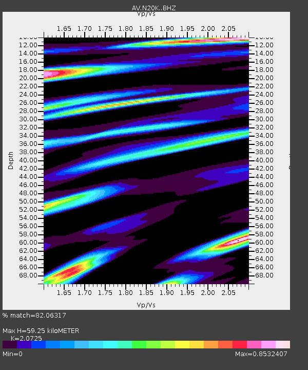
| Estimated Moho Depth: |
59.25 km |
| Estimated Crust Vp/Vs: |
2.07 |
| Assumed Crust Vp: |
6.566 km/s |
| Estimated Crust Vs: |
3.168 km/s |
| Estimated Crust Poisson's Ratio: |
0.35 |
|
| Radial Match: |
82.06317 % |
| Radial Bump: |
400 |
| Transverse Match: |
79.57025 % |
| Transverse Bump: |
400 |
| SOD ConfigId: |
25131211 |
| Insert Time: |
2021-10-21 13:48:44.867 +0000 |
| GWidth: |
2.5 |
| Max Bumps: |
400 |
| Tol: |
0.001 |
|

Signal To Noise
| Channel | StoN | STA | LTA |
| AV:N20K: :BHZ:20211007T13:49:33.825003Z | 9.654523 | 1.4376734E-6 | 1.4891191E-7 |
| AV:N20K: :BHN:20211007T13:49:33.825003Z | 2.8832479 | 4.2740274E-7 | 1.4823657E-7 |
| AV:N20K: :BHE:20211007T13:49:33.825003Z | 3.0904686 | 5.84821E-7 | 1.8923377E-7 |
| Arrivals |
| Ps | 10 SECOND |
| PpPs | 26 SECOND |
| PsPs/PpSs | 37 SECOND |


