You are here: Home > Network List > AV - Alaska Volcano Observatory Stations List
> Station SPCR Ckakachatna River, Mount Spurr, Alaska > Earthquake Result Viewer
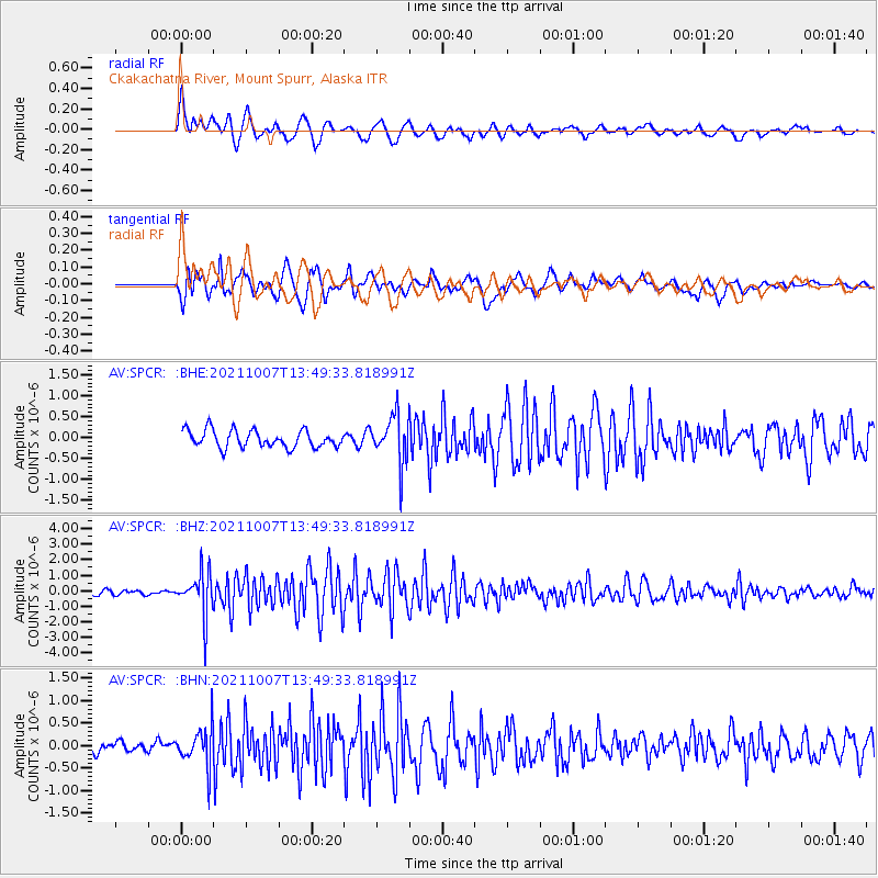
SPCR Ckakachatna River, Mount Spurr, Alaska - Earthquake Result Viewer
*The percent match for this event was below the threshold and hence no stack was calculated.
| Earthquake location: |
Near East Coast Of Honshu, Japan |
| Earthquake latitude/longitude: |
35.6/140.1 |
| Earthquake time(UTC): |
2021/10/07 (280) 13:41:24 GMT |
| Earthquake Depth: |
62 km |
| Earthquake Magnitude: |
5.9 mww |
| Earthquake Catalog/Contributor: |
NEIC PDE/us |
|
| Network: |
AV Alaska Volcano Observatory |
| Station: |
SPCR Ckakachatna River, Mount Spurr, Alaska |
| Lat/Lon: |
61.20 N/152.21 W |
| Elevation: |
984 m |
|
| Distance: |
49.0 deg |
| Az: |
36.435 deg |
| Baz: |
270.726 deg |
| Ray Param: |
$rayparam |
*The percent match for this event was below the threshold and hence was not used in the summary stack. |
|
| Radial Match: |
78.5849 % |
| Radial Bump: |
400 |
| Transverse Match: |
81.11374 % |
| Transverse Bump: |
400 |
| SOD ConfigId: |
25131211 |
| Insert Time: |
2021-10-21 13:49:17.758 +0000 |
| GWidth: |
2.5 |
| Max Bumps: |
400 |
| Tol: |
0.001 |
|
Signal To Noise
| Channel | StoN | STA | LTA |
| AV:SPCR: :BHZ:20211007T13:49:33.818991Z | 9.563148 | 1.4303906E-6 | 1.4957321E-7 |
| AV:SPCR: :BHN:20211007T13:49:33.818991Z | 3.0551887 | 4.2808705E-7 | 1.4011805E-7 |
| AV:SPCR: :BHE:20211007T13:49:33.818991Z | 2.8860533 | 5.9297554E-7 | 2.0546244E-7 |
| Arrivals |
| Ps | |
| PpPs | |
| PsPs/PpSs | |


