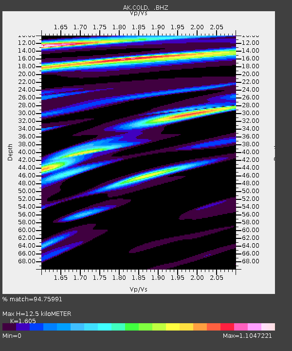
COLD Coldfoot Broadband - Earthquake Result Viewer
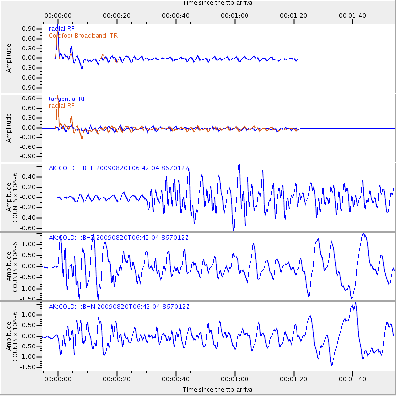
Earthquake location: Norwegian Sea
Earthquake latitude/longitude: 72.2/0.9
Earthquake time(UTC): 2009/08/20 (232) 06:35:04 GMT
Earthquake Depth: 6.0 km
Earthquake Magnitude: 5.9 MB, 5.7 MS, 6.0 MW, 6.0 MW
Earthquake Catalog/Contributor: WHDF/NEIC
Network: AK Alaska Regional Network
Station: COLD Coldfoot Broadband
Lat/Lon: 67.23 N/150.20 W
Elevation: 377 m
Distance: 39.5 deg
Az: 342.822 deg
Baz: 13.494 deg
Ray Param: 0.07495734
Estimated Moho Depth: 12.5 km
Estimated Crust Vp/Vs: 1.61
Assumed Crust Vp: 6.577 km/s
Estimated Crust Vs: 4.098 km/s
Estimated Crust Poisson's Ratio: 0.18
Radial Match: 94.75991 %
Radial Bump: 400
Transverse Match: 78.18368 %
Transverse Bump: 400
SOD ConfigId: 2622
Insert Time: 2010-03-09 13:25:58.578 +0000
GWidth: 2.5
Max Bumps: 400
Tol: 0.001

Signal To Noise

ChannelStoNSTALTA
AK:COLD: :BHZ:20090820T06:42:04.867012Z14.2652185.8616683E-74.1090633E-8
AK:COLD: :BHN:20090820T06:42:04.867012Z5.29200653.595414E-76.794046E-8
AK:COLD: :BHE:20090820T06:42:04.867012Z2.68072991.1869726E-74.427796E-8
Arrivals
Ps1.2 SECOND
PpPs4.6 SECOND
PsPs/PpSs5.8 SECOND