You are here: Home > Network List > CC - Cascade Chain Volcano Monitoring Stations List
> Station OBSR Observation Rock, Mt. Rainier, WA > Earthquake Result Viewer
OBSR Observation Rock, Mt. Rainier, WA - Earthquake Result Viewer
| Earthquake location: |
Near East Coast Of Honshu, Japan |
| Earthquake latitude/longitude: |
35.6/140.1 |
| Earthquake time(UTC): |
2021/10/07 (280) 13:41:24 GMT |
| Earthquake Depth: |
62 km |
| Earthquake Magnitude: |
5.9 mww |
| Earthquake Catalog/Contributor: |
NEIC PDE/us |
|
| Network: |
CC Cascade Chain Volcano Monitoring |
| Station: |
OBSR Observation Rock, Mt. Rainier, WA |
| Lat/Lon: |
46.90 N/121.82 W |
| Elevation: |
2382 m |
|
| Distance: |
69.9 deg |
| Az: |
46.281 deg |
| Baz: |
300.763 deg |
| Ray Param: |
0.055190507 |
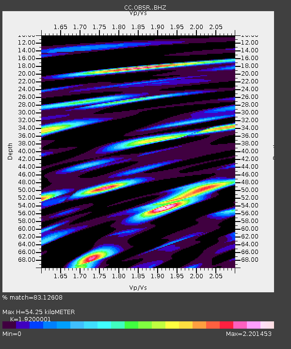
| Estimated Moho Depth: |
54.25 km |
| Estimated Crust Vp/Vs: |
1.92 |
| Assumed Crust Vp: |
6.597 km/s |
| Estimated Crust Vs: |
3.436 km/s |
| Estimated Crust Poisson's Ratio: |
0.31 |
|
| Radial Match: |
83.12608 % |
| Radial Bump: |
400 |
| Transverse Match: |
81.64072 % |
| Transverse Bump: |
400 |
| SOD ConfigId: |
25131211 |
| Insert Time: |
2021-10-21 13:51:29.131 +0000 |
| GWidth: |
2.5 |
| Max Bumps: |
400 |
| Tol: |
0.001 |
|

Signal To Noise
| Channel | StoN | STA | LTA |
| CC:OBSR: :BHZ:20211007T13:51:58.045004Z | 8.439384 | 1.2630078E-6 | 1.496564E-7 |
| CC:OBSR: :BHN:20211007T13:51:58.045004Z | 7.437158 | 9.080207E-7 | 1.2209243E-7 |
| CC:OBSR: :BHE:20211007T13:51:58.045004Z | 2.891633 | 5.3682294E-7 | 1.8564697E-7 |
| Arrivals |
| Ps | 7.8 SECOND |
| PpPs | 23 SECOND |
| PsPs/PpSs | 31 SECOND |


