You are here: Home > Network List > YL01 - Himalayan Nepal Tibet Experiment Stations List
> Station PHID YL.PHID > Earthquake Result Viewer
PHID YL.PHID - Earthquake Result Viewer
| Earthquake location: |
E. Russia-N.E. China Border Reg. |
| Earthquake latitude/longitude: |
43.8/130.7 |
| Earthquake time(UTC): |
2002/06/28 (179) 17:19:30 GMT |
| Earthquake Depth: |
566 km |
| Earthquake Magnitude: |
6.7 MB, 7.3 MW, 7.3 MW |
| Earthquake Catalog/Contributor: |
WHDF/NEIC |
|
| Network: |
YL Himalayan Nepal Tibet Experiment |
| Station: |
PHID YL.PHID |
| Lat/Lon: |
27.15 N/87.76 E |
| Elevation: |
1176 m |
|
| Distance: |
38.2 deg |
| Az: |
258.73 deg |
| Baz: |
52.899 deg |
| Ray Param: |
0.07283615 |
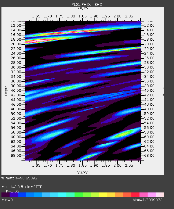
| Estimated Moho Depth: |
18.5 km |
| Estimated Crust Vp/Vs: |
1.65 |
| Assumed Crust Vp: |
6.236 km/s |
| Estimated Crust Vs: |
3.779 km/s |
| Estimated Crust Poisson's Ratio: |
0.21 |
|
| Radial Match: |
90.65092 % |
| Radial Bump: |
400 |
| Transverse Match: |
70.94895 % |
| Transverse Bump: |
400 |
| SOD ConfigId: |
16844 |
| Insert Time: |
2010-02-26 16:04:10.836 +0000 |
| GWidth: |
2.5 |
| Max Bumps: |
400 |
| Tol: |
0.001 |
|
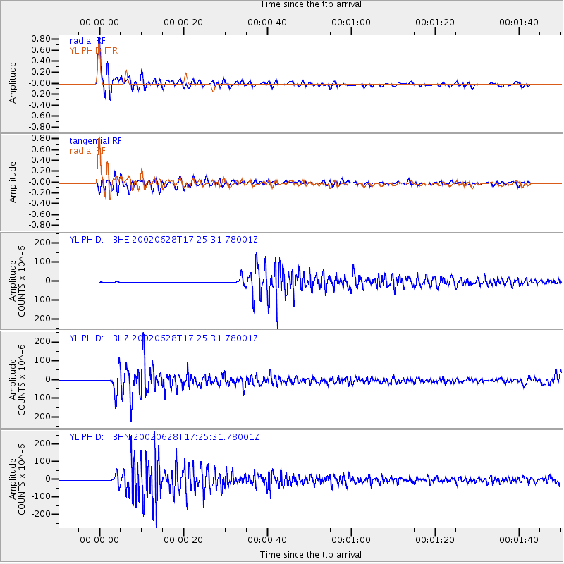
Signal To Noise
| Channel | StoN | STA | LTA |
| YL:PHID: :BHZ:20020628T17:25:31.78001Z | 170.4017 | 5.1201052E-5 | 3.0047266E-7 |
| YL:PHID: :BHN:20020628T17:25:31.78001Z | 126.2695 | 2.2004375E-5 | 1.7426515E-7 |
| YL:PHID: :BHE:20020628T17:25:31.78001Z | 100.396355 | 1.7193532E-5 | 1.7125652E-7 |
| Arrivals |
| Ps | 2.1 SECOND |
| PpPs | 7.3 SECOND |
| PsPs/PpSs | 9.4 SECOND |


