You are here: Home > Network List > CI - Caltech Regional Seismic Network Stations List
> Station MPM Manuel Prospect Mine, California, USA > Earthquake Result Viewer
MPM Manuel Prospect Mine, California, USA - Earthquake Result Viewer
*The percent match for this event was below the threshold and hence no stack was calculated.
| Earthquake location: |
Near East Coast Of Honshu, Japan |
| Earthquake latitude/longitude: |
35.6/140.1 |
| Earthquake time(UTC): |
2021/10/07 (280) 13:41:24 GMT |
| Earthquake Depth: |
62 km |
| Earthquake Magnitude: |
5.9 mww |
| Earthquake Catalog/Contributor: |
NEIC PDE/us |
|
| Network: |
CI Caltech Regional Seismic Network |
| Station: |
MPM Manuel Prospect Mine, California, USA |
| Lat/Lon: |
36.06 N/117.49 W |
| Elevation: |
185 m |
|
| Distance: |
78.6 deg |
| Az: |
53.83 deg |
| Baz: |
305.686 deg |
| Ray Param: |
$rayparam |
*The percent match for this event was below the threshold and hence was not used in the summary stack. |
|
| Radial Match: |
59.890186 % |
| Radial Bump: |
400 |
| Transverse Match: |
73.08845 % |
| Transverse Bump: |
400 |
| SOD ConfigId: |
25131211 |
| Insert Time: |
2021-10-21 13:53:13.371 +0000 |
| GWidth: |
2.5 |
| Max Bumps: |
400 |
| Tol: |
0.001 |
|
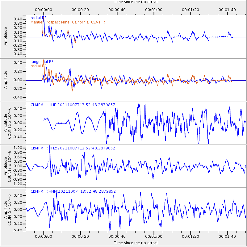
Signal To Noise
| Channel | StoN | STA | LTA |
| CI:MPM: :HHZ:20211007T13:52:48.287985Z | 2.1255846 | 4.07547E-7 | 1.9173407E-7 |
| CI:MPM: :HHN:20211007T13:52:48.287985Z | 1.6859089 | 1.874393E-7 | 1.11179965E-7 |
| CI:MPM: :HHE:20211007T13:52:48.287985Z | 1.9297351 | 2.6651995E-7 | 1.381122E-7 |
| Arrivals |
| Ps | |
| PpPs | |
| PsPs/PpSs | |


