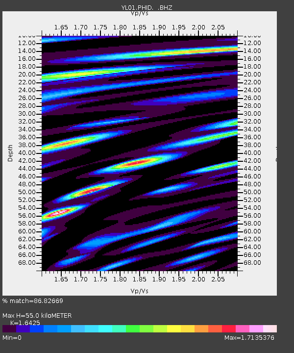
PHID YL.PHID - Earthquake Result Viewer
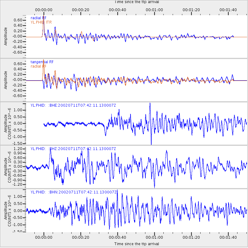
Earthquake location: Taiwan Region
Earthquake latitude/longitude: 24.1/122.3
Earthquake time(UTC): 2002/07/11 (192) 07:36:26 GMT
Earthquake Depth: 44 km
Earthquake Magnitude: 5.6 MB, 5.6 MS, 5.8 MW, 5.8 MW
Earthquake Catalog/Contributor: WHDF/NEIC
Network: YL Himalayan Nepal Tibet Experiment
Station: PHID YL.PHID
Lat/Lon: 27.15 N/87.76 E
Elevation: 1176 m
Distance: 31.2 deg
Az: 283.052 deg
Baz: 87.828 deg
Ray Param: 0.07907432
Estimated Moho Depth: 55.0 km
Estimated Crust Vp/Vs: 1.64
Assumed Crust Vp: 6.236 km/s
Estimated Crust Vs: 3.797 km/s
Estimated Crust Poisson's Ratio: 0.21
Radial Match: 86.82669 %
Radial Bump: 400
Transverse Match: 70.18248 %
Transverse Bump: 400
SOD ConfigId: 16844
Insert Time: 2010-02-26 16:04:12.322 +0000
GWidth: 2.5
Max Bumps: 400
Tol: 0.001

Signal To Noise

ChannelStoNSTALTA
YL:PHID: :BHZ:20020711T07:42:11.130007Z7.35907274.4988073E-76.11328E-8
YL:PHID: :BHN:20020711T07:42:11.130007Z1.23663381.1453156E-79.261558E-8
YL:PHID: :BHE:20020711T07:42:11.130007Z4.1306643.1895337E-77.721601E-8
Arrivals
Ps6.1 SECOND
PpPs21 SECOND
PsPs/PpSs28 SECOND