You are here: Home > Network List > CN - Canadian National Seismograph Network Stations List
> Station INK INUVIK, NT > Earthquake Result Viewer
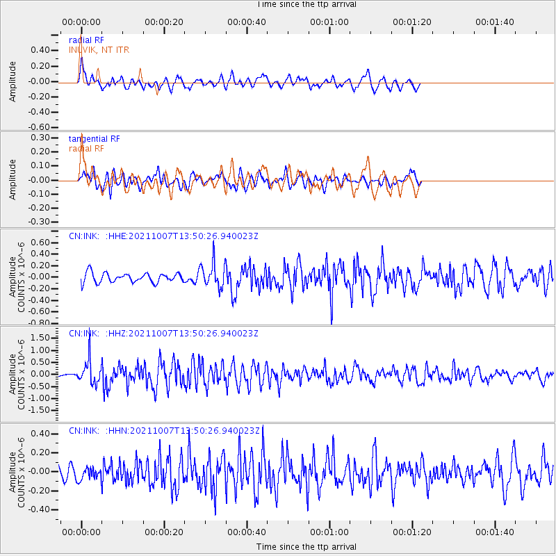
INK INUVIK, NT - Earthquake Result Viewer
*The percent match for this event was below the threshold and hence no stack was calculated.
| Earthquake location: |
Near East Coast Of Honshu, Japan |
| Earthquake latitude/longitude: |
35.6/140.1 |
| Earthquake time(UTC): |
2021/10/07 (280) 13:41:24 GMT |
| Earthquake Depth: |
62 km |
| Earthquake Magnitude: |
5.9 mww |
| Earthquake Catalog/Contributor: |
NEIC PDE/us |
|
| Network: |
CN Canadian National Seismograph Network |
| Station: |
INK INUVIK, NT |
| Lat/Lon: |
68.31 N/133.53 W |
| Elevation: |
44 m |
|
| Distance: |
56.2 deg |
| Az: |
26.531 deg |
| Baz: |
281.623 deg |
| Ray Param: |
$rayparam |
*The percent match for this event was below the threshold and hence was not used in the summary stack. |
|
| Radial Match: |
74.2121 % |
| Radial Bump: |
400 |
| Transverse Match: |
65.75915 % |
| Transverse Bump: |
400 |
| SOD ConfigId: |
25131211 |
| Insert Time: |
2021-10-21 13:54:50.657 +0000 |
| GWidth: |
2.5 |
| Max Bumps: |
400 |
| Tol: |
0.001 |
|
Signal To Noise
| Channel | StoN | STA | LTA |
| CN:INK: :HHZ:20211007T13:50:26.940023Z | 5.07747 | 5.131913E-7 | 1.0107226E-7 |
| CN:INK: :HHN:20211007T13:50:26.940023Z | 0.91753274 | 6.032502E-8 | 6.5746995E-8 |
| CN:INK: :HHE:20211007T13:50:26.940023Z | 2.5491283 | 2.1054933E-7 | 8.25966E-8 |
| Arrivals |
| Ps | |
| PpPs | |
| PsPs/PpSs | |


