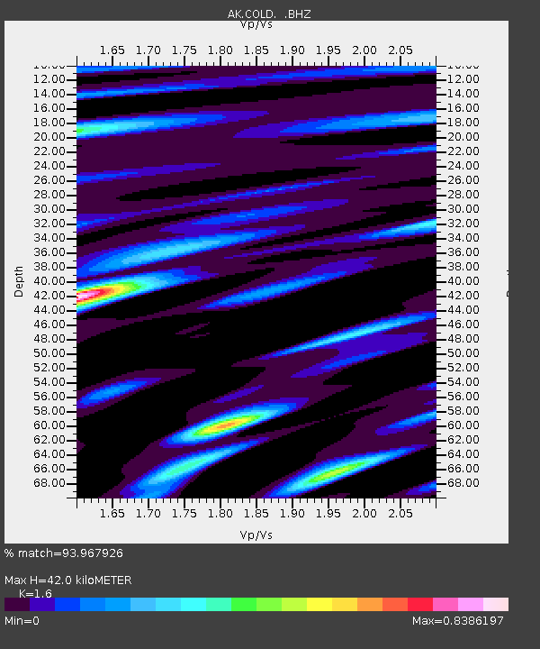
COLD Coldfoot Broadband - Earthquake Result Viewer

Earthquake location: Talaud Islands, Indonesia
Earthquake latitude/longitude: 3.9/126.4
Earthquake time(UTC): 2009/02/11 (042) 17:34:50 GMT
Earthquake Depth: 22 km
Earthquake Magnitude: 6.6 MB, 7.2 MS, 7.2 MW, 7.1 MW
Earthquake Catalog/Contributor: WHDF/NEIC
Network: AK Alaska Regional Network
Station: COLD Coldfoot Broadband
Lat/Lon: 67.23 N/150.20 W
Elevation: 377 m
Distance: 83.9 deg
Az: 22.888 deg
Baz: 265.419 deg
Ray Param: 0.045851376
Estimated Moho Depth: 42.0 km
Estimated Crust Vp/Vs: 1.60
Assumed Crust Vp: 6.577 km/s
Estimated Crust Vs: 4.11 km/s
Estimated Crust Poisson's Ratio: 0.18
Radial Match: 93.967926 %
Radial Bump: 400
Transverse Match: 90.316124 %
Transverse Bump: 400
SOD ConfigId: 2658
Insert Time: 2010-03-09 13:26:22.505 +0000
GWidth: 2.5
Max Bumps: 400
Tol: 0.001

Signal To Noise

ChannelStoNSTALTA
AK:COLD: :BHZ:20090211T17:46:47.328015Z19.899723.1467157E-61.5812866E-7
AK:COLD: :BHN:20090211T17:46:47.328015Z3.75094272.535514E-76.7596716E-8
AK:COLD: :BHE:20090211T17:46:47.328015Z8.7113961.0863225E-61.247013E-7
Arrivals
Ps3.9 SECOND
PpPs16 SECOND
PsPs/PpSs20 SECOND