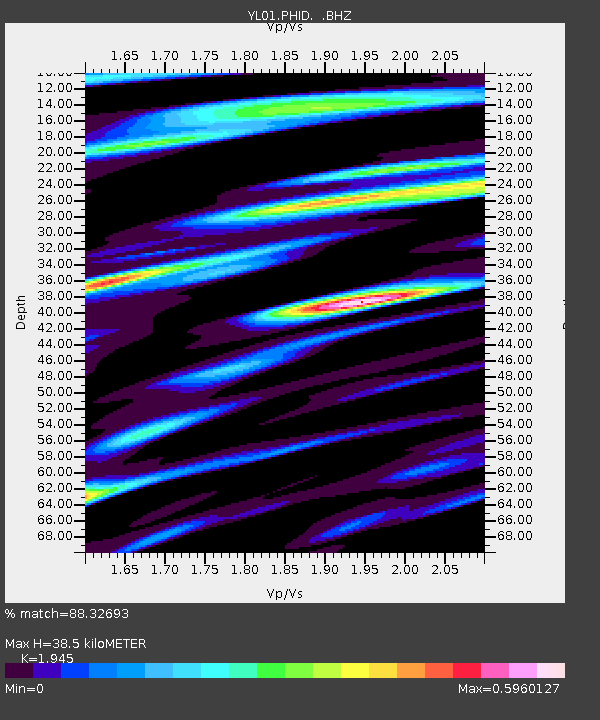
PHID YL.PHID - Earthquake Result Viewer
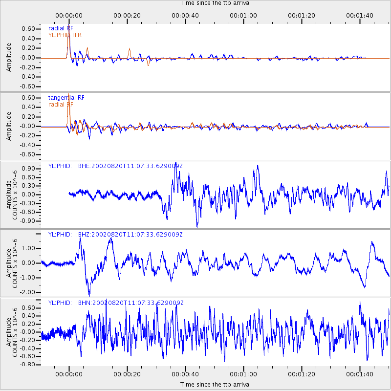
Earthquake location: Southeast Of Honshu, Japan
Earthquake latitude/longitude: 31.0/142.0
Earthquake time(UTC): 2002/08/20 (232) 10:59:32 GMT
Earthquake Depth: 9.0 km
Earthquake Magnitude: 5.4 MB, 6.2 MS, 6.3 MW, 6.1 MW
Earthquake Catalog/Contributor: WHDF/NEIC
Network: YL Himalayan Nepal Tibet Experiment
Station: PHID YL.PHID
Lat/Lon: 27.15 N/87.76 E
Elevation: 1176 m
Distance: 47.1 deg
Az: 279.644 deg
Baz: 71.842 deg
Ray Param: 0.070187874
Estimated Moho Depth: 38.5 km
Estimated Crust Vp/Vs: 1.95
Assumed Crust Vp: 6.236 km/s
Estimated Crust Vs: 3.206 km/s
Estimated Crust Poisson's Ratio: 0.32
Radial Match: 88.32693 %
Radial Bump: 400
Transverse Match: 67.96448 %
Transverse Bump: 400
SOD ConfigId: 16844
Insert Time: 2010-02-26 16:04:18.175 +0000
GWidth: 2.5
Max Bumps: 400
Tol: 0.001

Signal To Noise

ChannelStoNSTALTA
YL:PHID: :BHZ:20020820T11:07:33.629009Z7.52199176.1975334E-78.2392184E-8
YL:PHID: :BHN:20020820T11:07:33.629009Z2.32871632.0698423E-78.88834E-8
YL:PHID: :BHE:20020820T11:07:33.629009Z4.4602553.7156914E-78.33067E-8
Arrivals
Ps6.1 SECOND
PpPs17 SECOND
PsPs/PpSs23 SECOND