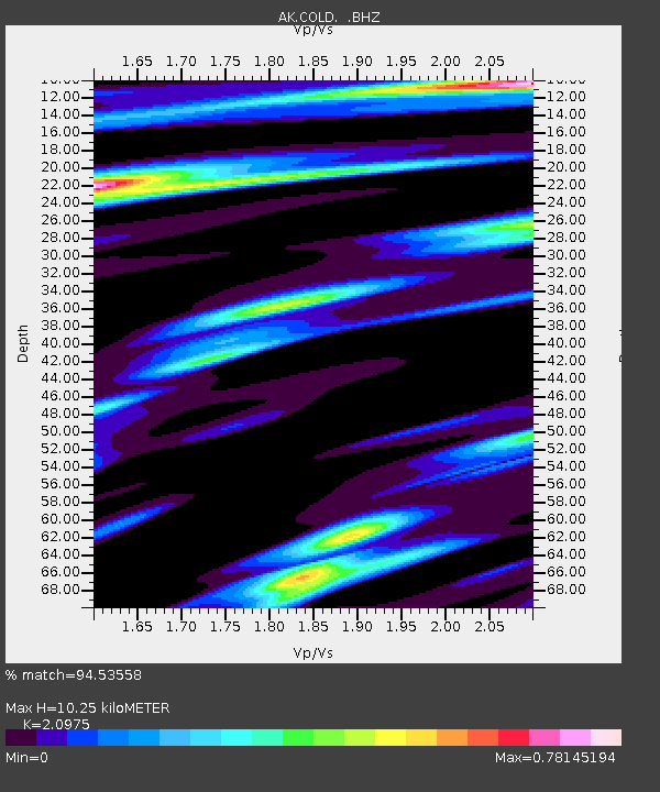
COLD Coldfoot Broadband - Earthquake Result Viewer

Earthquake location: Tonga Islands
Earthquake latitude/longitude: -21.9/-173.8
Earthquake time(UTC): 2008/10/19 (293) 05:10:33 GMT
Earthquake Depth: 29 km
Earthquake Magnitude: 6.8 MB, 7.0 MS, 6.9 MW, 6.9 MW
Earthquake Catalog/Contributor: WHDF/NEIC
Network: AK Alaska Regional Network
Station: COLD Coldfoot Broadband
Lat/Lon: 67.23 N/150.20 W
Elevation: 377 m
Distance: 90.6 deg
Az: 8.973 deg
Baz: 201.85 deg
Ray Param: 0.041661743
Estimated Moho Depth: 10.25 km
Estimated Crust Vp/Vs: 2.10
Assumed Crust Vp: 6.577 km/s
Estimated Crust Vs: 3.136 km/s
Estimated Crust Poisson's Ratio: 0.35
Radial Match: 94.53558 %
Radial Bump: 342
Transverse Match: 84.65536 %
Transverse Bump: 400
SOD ConfigId: 2560
Insert Time: 2010-03-09 13:27:17.960 +0000
GWidth: 2.5
Max Bumps: 400
Tol: 0.001

Signal To Noise

ChannelStoNSTALTA
AK:COLD: :BHZ:20081019T05:23:01.80801Z31.4703564.577138E-61.4544284E-7
AK:COLD: :BHN:20081019T05:23:01.80801Z15.05950451.3704811E-69.100439E-8
AK:COLD: :BHE:20081019T05:23:01.80801Z5.06276231.0890569E-62.1511123E-7
Arrivals
Ps1.7 SECOND
PpPs4.7 SECOND
PsPs/PpSs6.5 SECOND