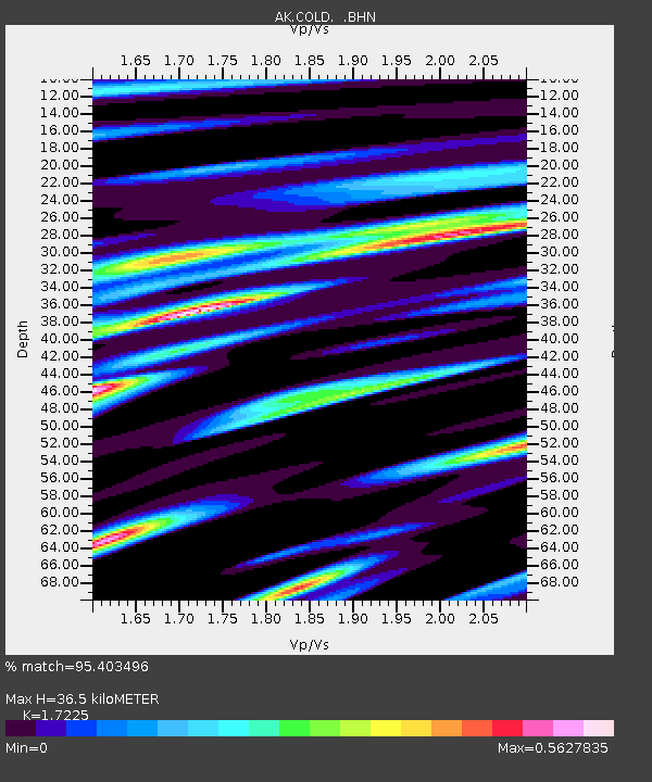
COLD Coldfoot Broadband - Earthquake Result Viewer
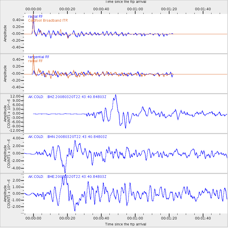
Earthquake location: Southern Xinjiang, China
Earthquake latitude/longitude: 35.5/81.5
Earthquake time(UTC): 2008/03/20 (080) 22:32:57 GMT
Earthquake Depth: 10 km
Earthquake Magnitude: 6.3 MB, 7.3 MS, 7.2 MW, 7.1 MW
Earthquake Catalog/Contributor: WHDF/NEIC
Network: AK Alaska Regional Network
Station: COLD Coldfoot Broadband
Lat/Lon: 67.23 N/150.20 W
Elevation: 377 m
Distance: 70.4 deg
Az: 18.914 deg
Baz: 317.196 deg
Ray Param: 0.055004198
Estimated Moho Depth: 36.5 km
Estimated Crust Vp/Vs: 1.72
Assumed Crust Vp: 6.577 km/s
Estimated Crust Vs: 3.818 km/s
Estimated Crust Poisson's Ratio: 0.25
Radial Match: 95.403496 %
Radial Bump: 400
Transverse Match: 79.60954 %
Transverse Bump: 400
SOD ConfigId: 2564
Insert Time: 2010-03-09 13:27:19.223 +0000
GWidth: 2.5
Max Bumps: 400
Tol: 0.001

Signal To Noise

ChannelStoNSTALTA
AK:COLD: :BHN:20080320T22:43:40.84803Z1.91107732.1994389E-71.1508895E-7
AK:COLD: :BHE:20080320T22:43:40.84803Z1.22700121.5938913E-71.2990137E-7
AK:COLD: :BHZ:20080320T22:43:40.84803Z5.80400235.437934E-79.369283E-8
Arrivals
Ps4.2 SECOND
PpPs15 SECOND
PsPs/PpSs19 SECOND