You are here: Home > Network List > TM - Thai Seismic Monitoring Network Stations List
> Station CMAI AngKang, ChiangMai > Earthquake Result Viewer
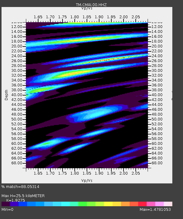
CMAI AngKang, ChiangMai - Earthquake Result Viewer
| Earthquake location: |
Near East Coast Of Honshu, Japan |
| Earthquake latitude/longitude: |
35.6/140.1 |
| Earthquake time(UTC): |
2021/10/07 (280) 13:41:24 GMT |
| Earthquake Depth: |
62 km |
| Earthquake Magnitude: |
5.9 mww |
| Earthquake Catalog/Contributor: |
NEIC PDE/us |
|
| Network: |
TM Thai Seismic Monitoring Network |
| Station: |
CMAI AngKang, ChiangMai |
| Lat/Lon: |
19.93 N/99.05 E |
| Elevation: |
1544 m |
|
| Distance: |
39.2 deg |
| Az: |
257.722 deg |
| Baz: |
57.858 deg |
| Ray Param: |
0.07493259 |
| Estimated Moho Depth: |
25.5 km |
| Estimated Crust Vp/Vs: |
1.93 |
| Assumed Crust Vp: |
6.35 km/s |
| Estimated Crust Vs: |
3.294 km/s |
| Estimated Crust Poisson's Ratio: |
0.32 |
|
| Radial Match: |
88.05314 % |
| Radial Bump: |
400 |
| Transverse Match: |
77.01387 % |
| Transverse Bump: |
400 |
| SOD ConfigId: |
25131211 |
| Insert Time: |
2021-10-21 14:07:07.611 +0000 |
| GWidth: |
2.5 |
| Max Bumps: |
400 |
| Tol: |
0.001 |
|

Signal To Noise
| Channel | StoN | STA | LTA |
| TM:CMAI:00:HHZ:20211007T13:48:16.129995Z | 12.559916 | 9.955189E-7 | 7.9261596E-8 |
| TM:CMAI:00:HHN:20211007T13:48:16.129995Z | 4.3466477 | 4.5059681E-7 | 1.03665364E-7 |
| TM:CMAI:00:HHE:20211007T13:48:16.129995Z | 8.051751 | 6.112076E-7 | 7.5909895E-8 |
| Arrivals |
| Ps | 4.0 SECOND |
| PpPs | 11 SECOND |
| PsPs/PpSs | 15 SECOND |


