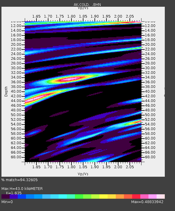
COLD Coldfoot Broadband - Earthquake Result Viewer

Earthquake location: New Ireland Region, P.N.G.
Earthquake latitude/longitude: -3.6/151.0
Earthquake time(UTC): 2007/06/18 (169) 06:18:48 GMT
Earthquake Depth: 26 km
Earthquake Magnitude: 5.7 MB, 6.2 MS, 6.3 MW, 6.1 MW
Earthquake Catalog/Contributor: WHDF/NEIC
Network: AK Alaska Regional Network
Station: COLD Coldfoot Broadband
Lat/Lon: 67.23 N/150.20 W
Elevation: 377 m
Distance: 81.7 deg
Az: 19.673 deg
Baz: 239.672 deg
Ray Param: 0.04736228
Estimated Moho Depth: 43.0 km
Estimated Crust Vp/Vs: 1.63
Assumed Crust Vp: 6.577 km/s
Estimated Crust Vs: 4.022 km/s
Estimated Crust Poisson's Ratio: 0.20
Radial Match: 94.32605 %
Radial Bump: 400
Transverse Match: 85.724915 %
Transverse Bump: 400
SOD ConfigId: 2564
Insert Time: 2010-03-09 13:27:30.761 +0000
GWidth: 2.5
Max Bumps: 400
Tol: 0.001

Signal To Noise

ChannelStoNSTALTA
AK:COLD: :BHN:20070618T06:30:33.166018Z0.99545712.7108161E-82.7231874E-8
AK:COLD: :BHE:20070618T06:30:33.166018Z12.2645482.5243256E-72.0582297E-8
AK:COLD: :BHZ:20070618T06:30:33.166018Z12.6283017.0203237E-75.559199E-8
Arrivals
Ps4.3 SECOND
PpPs17 SECOND
PsPs/PpSs21 SECOND