You are here: Home > Network List > TX - Texas Seismological Network Stations List
> Station WTFS Witchita Falls > Earthquake Result Viewer
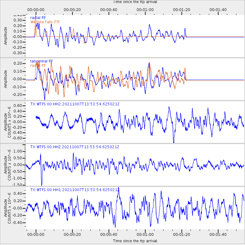
WTFS Witchita Falls - Earthquake Result Viewer
*The percent match for this event was below the threshold and hence no stack was calculated.
| Earthquake location: |
Near East Coast Of Honshu, Japan |
| Earthquake latitude/longitude: |
35.6/140.1 |
| Earthquake time(UTC): |
2021/10/07 (280) 13:41:24 GMT |
| Earthquake Depth: |
62 km |
| Earthquake Magnitude: |
5.9 mww |
| Earthquake Catalog/Contributor: |
NEIC PDE/us |
|
| Network: |
TX Texas Seismological Network |
| Station: |
WTFS Witchita Falls |
| Lat/Lon: |
33.77 N/98.46 W |
| Elevation: |
277 m |
|
| Distance: |
91.9 deg |
| Az: |
45.334 deg |
| Baz: |
315.888 deg |
| Ray Param: |
$rayparam |
*The percent match for this event was below the threshold and hence was not used in the summary stack. |
|
| Radial Match: |
61.57897 % |
| Radial Bump: |
400 |
| Transverse Match: |
58.712906 % |
| Transverse Bump: |
344 |
| SOD ConfigId: |
25131211 |
| Insert Time: |
2021-10-21 14:08:02.519 +0000 |
| GWidth: |
2.5 |
| Max Bumps: |
400 |
| Tol: |
0.001 |
|
Signal To Noise
| Channel | StoN | STA | LTA |
| TX:WTFS:00:HHZ:20211007T13:53:54.625021Z | 4.055692 | 5.125684E-7 | 1.2638247E-7 |
| TX:WTFS:00:HH1:20211007T13:53:54.625021Z | 0.9896201 | 1.3473517E-7 | 1.3614837E-7 |
| TX:WTFS:00:HH2:20211007T13:53:54.625021Z | 1.0583267 | 1.6945012E-7 | 1.6011136E-7 |
| Arrivals |
| Ps | |
| PpPs | |
| PsPs/PpSs | |


