You are here: Home > Network List > US - United States National Seismic Network Stations List
> Station SCIA State Center, Iowa, USA > Earthquake Result Viewer
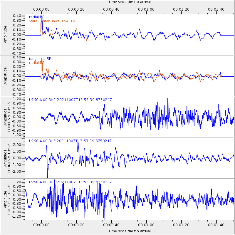
SCIA State Center, Iowa, USA - Earthquake Result Viewer
*The percent match for this event was below the threshold and hence no stack was calculated.
| Earthquake location: |
Near East Coast Of Honshu, Japan |
| Earthquake latitude/longitude: |
35.6/140.1 |
| Earthquake time(UTC): |
2021/10/07 (280) 13:41:24 GMT |
| Earthquake Depth: |
62 km |
| Earthquake Magnitude: |
5.9 mww |
| Earthquake Catalog/Contributor: |
NEIC PDE/us |
|
| Network: |
US United States National Seismic Network |
| Station: |
SCIA State Center, Iowa, USA |
| Lat/Lon: |
41.91 N/93.22 W |
| Elevation: |
312 m |
|
| Distance: |
88.7 deg |
| Az: |
36.784 deg |
| Baz: |
319.156 deg |
| Ray Param: |
$rayparam |
*The percent match for this event was below the threshold and hence was not used in the summary stack. |
|
| Radial Match: |
62.949345 % |
| Radial Bump: |
400 |
| Transverse Match: |
62.25156 % |
| Transverse Bump: |
400 |
| SOD ConfigId: |
25131211 |
| Insert Time: |
2021-10-21 14:09:39.572 +0000 |
| GWidth: |
2.5 |
| Max Bumps: |
400 |
| Tol: |
0.001 |
|
Signal To Noise
| Channel | StoN | STA | LTA |
| US:SCIA:00:BHZ:20211007T13:53:39.875021Z | 4.1034694 | 9.726734E-7 | 2.3703684E-7 |
| US:SCIA:00:BH1:20211007T13:53:39.875021Z | 1.4898815 | 3.8066221E-7 | 2.5549832E-7 |
| US:SCIA:00:BH2:20211007T13:53:39.875021Z | 1.4122057 | 2.6120026E-7 | 1.8495908E-7 |
| Arrivals |
| Ps | |
| PpPs | |
| PsPs/PpSs | |


