You are here: Home > Network List > US - United States National Seismic Network Stations List
> Station SDCO Great Sand Dunes National Park, Colorado, USA > Earthquake Result Viewer
SDCO Great Sand Dunes National Park, Colorado, USA - Earthquake Result Viewer
| Earthquake location: |
Southern Bolivia |
| Earthquake latitude/longitude: |
-20.7/-63.0 |
| Earthquake time(UTC): |
2018/04/02 (092) 13:40:34 GMT |
| Earthquake Depth: |
562 km |
| Earthquake Magnitude: |
6.8 Mww |
| Earthquake Catalog/Contributor: |
NEIC PDE/us |
|
| Network: |
US United States National Seismic Network |
| Station: |
SDCO Great Sand Dunes National Park, Colorado, USA |
| Lat/Lon: |
37.75 N/105.50 W |
| Elevation: |
2569 m |
|
| Distance: |
70.5 deg |
| Az: |
325.392 deg |
| Baz: |
137.856 deg |
| Ray Param: |
0.05303305 |
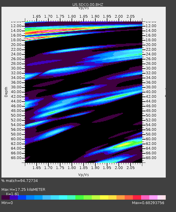
| Estimated Moho Depth: |
17.25 km |
| Estimated Crust Vp/Vs: |
1.61 |
| Assumed Crust Vp: |
6.316 km/s |
| Estimated Crust Vs: |
3.923 km/s |
| Estimated Crust Poisson's Ratio: |
0.19 |
|
| Radial Match: |
94.72734 % |
| Radial Bump: |
354 |
| Transverse Match: |
76.99582 % |
| Transverse Bump: |
400 |
| SOD ConfigId: |
2643891 |
| Insert Time: |
2018-04-16 13:50:52.326 +0000 |
| GWidth: |
2.5 |
| Max Bumps: |
400 |
| Tol: |
0.001 |
|
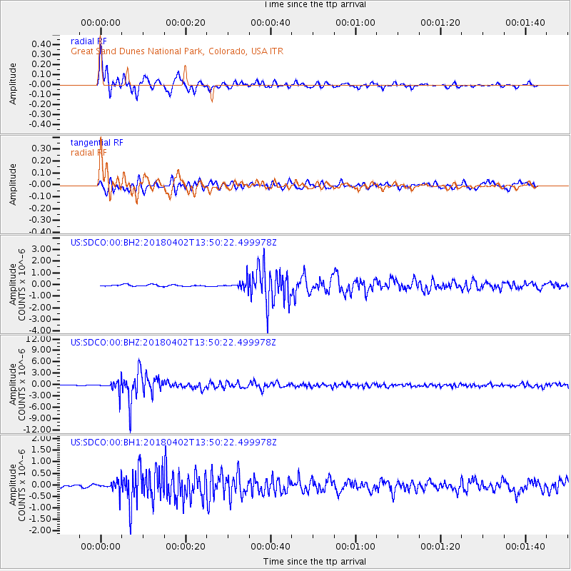
Signal To Noise
| Channel | StoN | STA | LTA |
| US:SDCO:00:BHZ:20180402T13:50:22.499978Z | 23.685863 | 1.4884549E-6 | 6.284149E-8 |
| US:SDCO:00:BH1:20180402T13:50:22.499978Z | 3.1098337 | 2.3465444E-7 | 7.545562E-8 |
| US:SDCO:00:BH2:20180402T13:50:22.499978Z | 5.4435744 | 3.7209466E-7 | 6.8354844E-8 |
| Arrivals |
| Ps | 1.7 SECOND |
| PpPs | 6.9 SECOND |
| PsPs/PpSs | 8.6 SECOND |


