You are here: Home > Network List > UU - University of Utah Regional Network Stations List
> Station CCUT Cedar City, UT, USA > Earthquake Result Viewer
CCUT Cedar City, UT, USA - Earthquake Result Viewer
| Earthquake location: |
Southern Bolivia |
| Earthquake latitude/longitude: |
-20.7/-63.0 |
| Earthquake time(UTC): |
2018/04/02 (092) 13:40:34 GMT |
| Earthquake Depth: |
562 km |
| Earthquake Magnitude: |
6.8 Mww |
| Earthquake Catalog/Contributor: |
NEIC PDE/us |
|
| Network: |
UU University of Utah Regional Network |
| Station: |
CCUT Cedar City, UT, USA |
| Lat/Lon: |
37.55 N/113.36 W |
| Elevation: |
2127 m |
|
| Distance: |
74.8 deg |
| Az: |
320.647 deg |
| Baz: |
131.653 deg |
| Ray Param: |
0.050283305 |
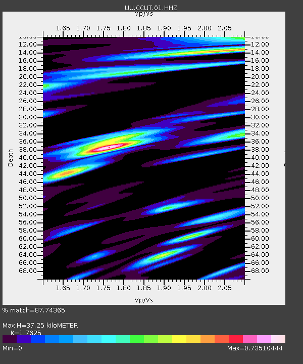
| Estimated Moho Depth: |
37.25 km |
| Estimated Crust Vp/Vs: |
1.76 |
| Assumed Crust Vp: |
6.194 km/s |
| Estimated Crust Vs: |
3.514 km/s |
| Estimated Crust Poisson's Ratio: |
0.26 |
|
| Radial Match: |
87.74365 % |
| Radial Bump: |
353 |
| Transverse Match: |
86.01754 % |
| Transverse Bump: |
370 |
| SOD ConfigId: |
2643891 |
| Insert Time: |
2018-04-16 13:51:05.838 +0000 |
| GWidth: |
2.5 |
| Max Bumps: |
400 |
| Tol: |
0.001 |
|
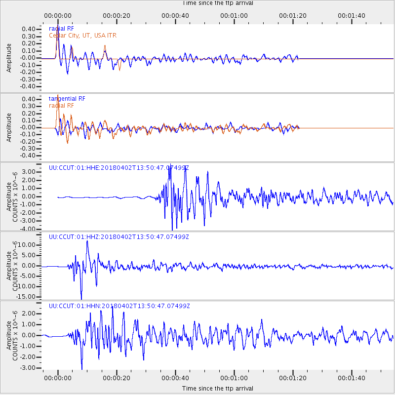
Signal To Noise
| Channel | StoN | STA | LTA |
| UU:CCUT:01:HHZ:20180402T13:50:47.07499Z | 2.8002288 | 3.7101293E-7 | 1.324938E-7 |
| UU:CCUT:01:HHN:20180402T13:50:47.07499Z | 0.71466666 | 7.737752E-8 | 1.0827079E-7 |
| UU:CCUT:01:HHE:20180402T13:50:47.07499Z | 3.1802273 | 1.462102E-7 | 4.597476E-8 |
| Arrivals |
| Ps | 4.7 SECOND |
| PpPs | 16 SECOND |
| PsPs/PpSs | 21 SECOND |


