You are here: Home > Network List > UU - University of Utah Regional Network Stations List
> Station CTU Camp Tracy, UT, USA > Earthquake Result Viewer
CTU Camp Tracy, UT, USA - Earthquake Result Viewer
| Earthquake location: |
Southern Bolivia |
| Earthquake latitude/longitude: |
-20.7/-63.0 |
| Earthquake time(UTC): |
2018/04/02 (092) 13:40:34 GMT |
| Earthquake Depth: |
562 km |
| Earthquake Magnitude: |
6.8 Mww |
| Earthquake Catalog/Contributor: |
NEIC PDE/us |
|
| Network: |
UU University of Utah Regional Network |
| Station: |
CTU Camp Tracy, UT, USA |
| Lat/Lon: |
40.69 N/111.75 W |
| Elevation: |
1731 m |
|
| Distance: |
76.0 deg |
| Az: |
323.911 deg |
| Baz: |
133.49 deg |
| Ray Param: |
0.04950319 |
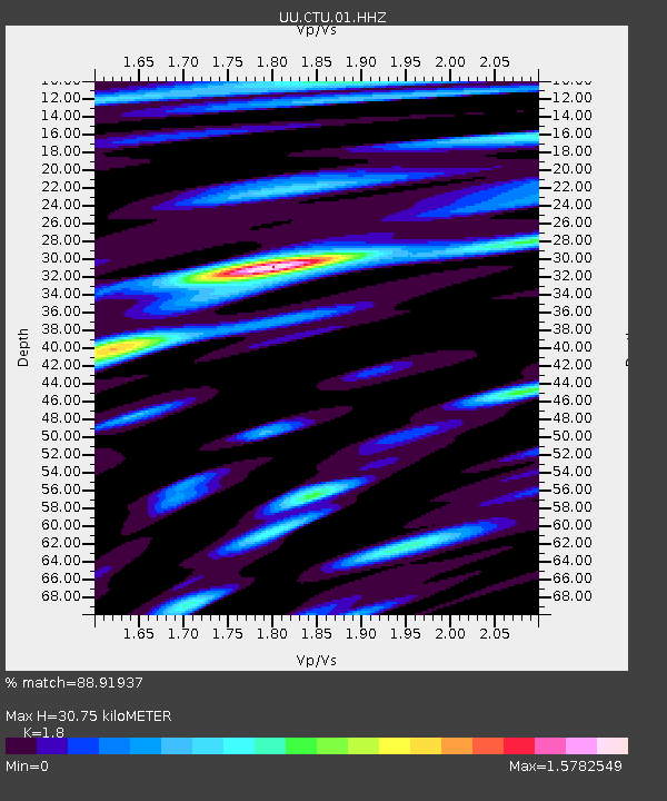
| Estimated Moho Depth: |
30.75 km |
| Estimated Crust Vp/Vs: |
1.80 |
| Assumed Crust Vp: |
6.155 km/s |
| Estimated Crust Vs: |
3.419 km/s |
| Estimated Crust Poisson's Ratio: |
0.28 |
|
| Radial Match: |
88.91937 % |
| Radial Bump: |
400 |
| Transverse Match: |
78.48654 % |
| Transverse Bump: |
400 |
| SOD ConfigId: |
2643891 |
| Insert Time: |
2018-04-16 13:51:08.982 +0000 |
| GWidth: |
2.5 |
| Max Bumps: |
400 |
| Tol: |
0.001 |
|

Signal To Noise
| Channel | StoN | STA | LTA |
| UU:CTU:01:HHZ:20180402T13:50:53.710Z | 6.0994434 | 2.5280137E-8 | 4.144663E-9 |
| UU:CTU:01:HHN:20180402T13:50:53.710Z | 1.9795825 | 6.625751E-9 | 3.3470446E-9 |
| UU:CTU:01:HHE:20180402T13:50:53.710Z | 1.0389987 | 4.943488E-9 | 4.7579345E-9 |
| Arrivals |
| Ps | 4.1 SECOND |
| PpPs | 14 SECOND |
| PsPs/PpSs | 18 SECOND |


