You are here: Home > Network List > YL01 - Himalayan Nepal Tibet Experiment Stations List
> Station PHID YL.PHID > Earthquake Result Viewer
PHID YL.PHID - Earthquake Result Viewer
| Earthquake location: |
Philippine Islands Region |
| Earthquake latitude/longitude: |
15.1/118.5 |
| Earthquake time(UTC): |
2002/10/12 (285) 23:43:12 GMT |
| Earthquake Depth: |
33 km |
| Earthquake Magnitude: |
5.6 MB, 5.6 MS, 6.1 MW |
| Earthquake Catalog/Contributor: |
WHDF/NEIC |
|
| Network: |
YL Himalayan Nepal Tibet Experiment |
| Station: |
PHID YL.PHID |
| Lat/Lon: |
27.15 N/87.76 E |
| Elevation: |
1176 m |
|
| Distance: |
31.0 deg |
| Az: |
297.809 deg |
| Baz: |
106.497 deg |
| Ray Param: |
0.07915565 |
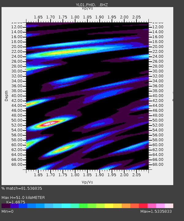
| Estimated Moho Depth: |
51.0 km |
| Estimated Crust Vp/Vs: |
1.70 |
| Assumed Crust Vp: |
6.236 km/s |
| Estimated Crust Vs: |
3.674 km/s |
| Estimated Crust Poisson's Ratio: |
0.23 |
|
| Radial Match: |
81.536835 % |
| Radial Bump: |
400 |
| Transverse Match: |
76.30642 % |
| Transverse Bump: |
400 |
| SOD ConfigId: |
16844 |
| Insert Time: |
2010-02-26 16:04:32.446 +0000 |
| GWidth: |
2.5 |
| Max Bumps: |
400 |
| Tol: |
0.001 |
|
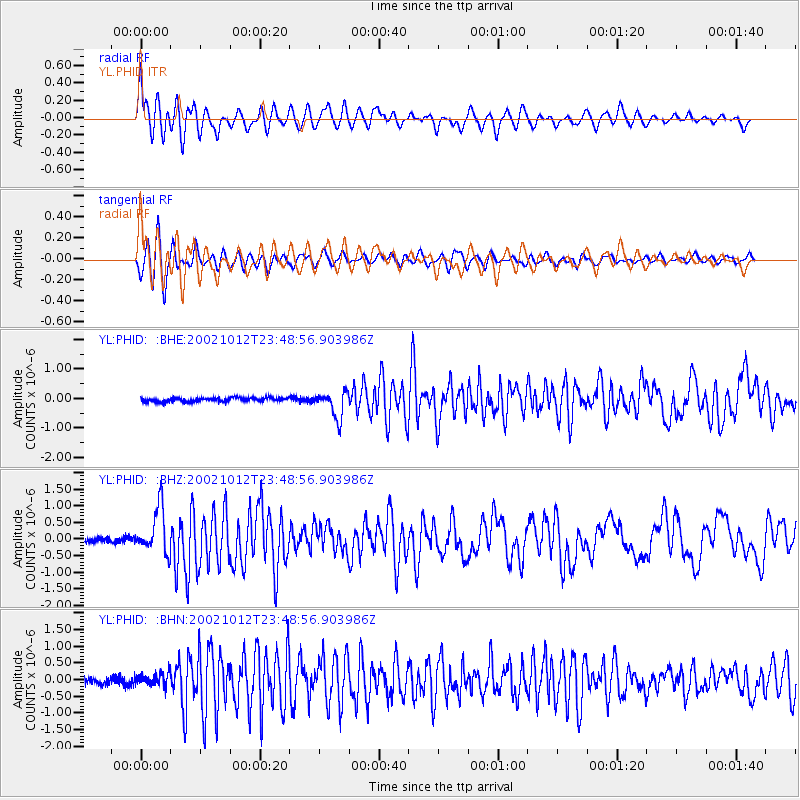
Signal To Noise
| Channel | StoN | STA | LTA |
| YL:PHID: :BHZ:20021012T23:48:56.903986Z | 7.160093 | 6.847984E-7 | 9.5641E-8 |
| YL:PHID: :BHN:20021012T23:48:56.903986Z | 2.1656156 | 1.924666E-7 | 8.8873854E-8 |
| YL:PHID: :BHE:20021012T23:48:56.903986Z | 6.7774444 | 4.5113194E-7 | 6.656372E-8 |
| Arrivals |
| Ps | 6.2 SECOND |
| PpPs | 20 SECOND |
| PsPs/PpSs | 27 SECOND |


