You are here: Home > Network List > YL01 - Himalayan Nepal Tibet Experiment Stations List
> Station PHID YL.PHID > Earthquake Result Viewer
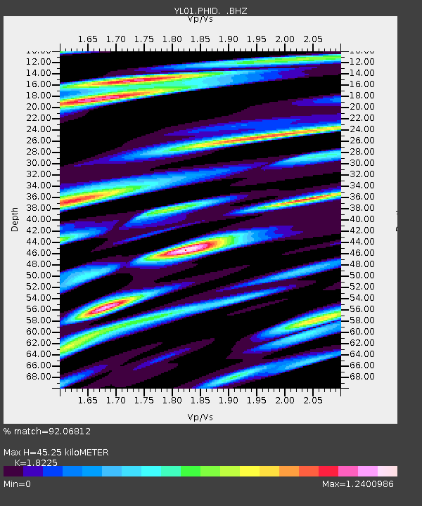
PHID YL.PHID - Earthquake Result Viewer
| Earthquake location: |
Hokkaido, Japan Region |
| Earthquake latitude/longitude: |
41.2/142.2 |
| Earthquake time(UTC): |
2002/10/14 (287) 14:12:43 GMT |
| Earthquake Depth: |
61 km |
| Earthquake Magnitude: |
5.9 MB, 6.1 MW, 6.1 MW |
| Earthquake Catalog/Contributor: |
WHDF/NEIC |
|
| Network: |
YL Himalayan Nepal Tibet Experiment |
| Station: |
PHID YL.PHID |
| Lat/Lon: |
27.15 N/87.76 E |
| Elevation: |
1176 m |
|
| Distance: |
46.5 deg |
| Az: |
270.25 deg |
| Baz: |
57.908 deg |
| Ray Param: |
0.07043509 |
| Estimated Moho Depth: |
45.25 km |
| Estimated Crust Vp/Vs: |
1.82 |
| Assumed Crust Vp: |
6.236 km/s |
| Estimated Crust Vs: |
3.422 km/s |
| Estimated Crust Poisson's Ratio: |
0.28 |
|
| Radial Match: |
92.06812 % |
| Radial Bump: |
400 |
| Transverse Match: |
81.65153 % |
| Transverse Bump: |
400 |
| SOD ConfigId: |
16844 |
| Insert Time: |
2010-02-26 16:04:35.090 +0000 |
| GWidth: |
2.5 |
| Max Bumps: |
400 |
| Tol: |
0.001 |
|

Signal To Noise
| Channel | StoN | STA | LTA |
| YL:PHID: :BHZ:20021014T14:20:34.355011Z | 38.477684 | 2.6373227E-6 | 6.854162E-8 |
| YL:PHID: :BHN:20021014T14:20:34.355011Z | 11.9031515 | 8.6210474E-7 | 7.2426594E-8 |
| YL:PHID: :BHE:20021014T14:20:34.355011Z | 18.668457 | 1.170724E-6 | 6.2711344E-8 |
| Arrivals |
| Ps | 6.3 SECOND |
| PpPs | 19 SECOND |
| PsPs/PpSs | 26 SECOND |


